Glass Coaster > Europe > United Kingdom > Scotland > Clackmannanshire > Clackmannan
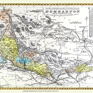
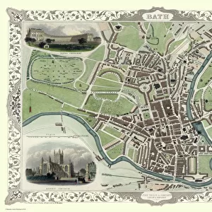
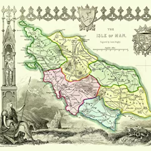
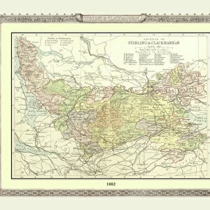
Glass Coaster : Old Map of the Counties of Stirling and Clackmannan from the Philips Handy Atlas of 1882


![]()
Home Decor from MapSeeker
Old Map of the Counties of Stirling and Clackmannan from the Philips Handy Atlas of 1882
PHA029
Welcome to the Mapseeker Image library and enter an historic gateway to one of the largest on-line collections of Historic Maps, Nostalgic Views, Vista's and Panorama's from a World gone by.
Media ID 20348201
County Map County Map Of Scotland Historic Map Old County Map Old Scottish County Map Scottish County Map Clackmannan Clackmannanshire Stirling Stirlingshire
Glass Coaster
Individual Glass Coaster. Stylish and elegant polished safety glass, toughened and heat resistant (10x10cm, 7mm thick). Price shown is per individual coaster.
Individual Glass Coaster. Elegant polished safety toughened glass and heat resistant, matching Place Mats are also available
Estimated Image Size (if not cropped) is 7.6cm x 6.1cm (3" x 2.4")
Estimated Product Size is 10cm x 10cm (3.9" x 3.9")
These are individually made so all sizes are approximate
Artwork printed orientated as per the preview above, with landscape (horizontal) orientation to match the source image.
FEATURES IN THESE COLLECTIONS
> Europe
> United Kingdom
> Scotland
> Clackmannanshire
> Clackmannan
> Europe
> United Kingdom
> Scotland
> Clackmannanshire
> Related Images
> Europe
> United Kingdom
> Scotland
> Maps
> Europe
> United Kingdom
> Scotland
> Posters
> Europe
> United Kingdom
> Scotland
> Related Images
> Europe
> United Kingdom
> Scotland
> Stirling
> Europe
> United Kingdom
> Scotland
> Stirlingshire
> Related Images
> Europe
> United Kingdom
> Scotland
> Stirlingshire
> Stirling
> Maps and Charts
> Early Maps
> Maps and Charts
> Related Images
> MapSeeker
> Maps from the British Isles
> Scotland and Counties PORTFOLIO
EDITORS COMMENTS
This print showcases an exquisite piece of history - the Old Map of the Counties of Stirling and Clackmannan from the Philips Handy Atlas of 1882 (PHA029). Steeped in Scottish heritage, this vintage county map offers a fascinating glimpse into the past. With intricate details and delicate craftsmanship, this old Scottish county map takes us on a journey through time. It reveals the boundaries and topography of Stirling and Clackmannan counties, providing a window into their rich historical significance. The map's aged appearance adds to its charm, evoking nostalgia for bygone eras. Stirlingshire, with its iconic city of Stirling at its heart, is beautifully depicted on this historic map. From rolling hills to winding rivers, every contour is meticulously illustrated. Meanwhile, Clackmannanshire's unique character shines through as it nestles between Fife and Perthshire. As we explore this remarkable piece of cartographic artistry, we are transported back to a time when these counties were bustling centers of activity. This visual treasure not only serves as a testament to Scotland's enduring legacy but also invites us to reflect upon our own place within history. Whether you have ancestral ties or simply appreciate the beauty of antique maps, this print captures the essence of Stirling and Clackmannan like no other. Display it proudly in your home or office space as a conversation starter that celebrates both local heritage and timeless craftsmanship.
MADE IN THE UK
Safe Shipping with 30 Day Money Back Guarantee
FREE PERSONALISATION*
We are proud to offer a range of customisation features including Personalised Captions, Color Filters and Picture Zoom Tools
SECURE PAYMENTS
We happily accept a wide range of payment options so you can pay for the things you need in the way that is most convenient for you
* Options may vary by product and licensing agreement. Zoomed Pictures can be adjusted in the Basket.