Glass Coaster > Arts > Artists > O > Oceanic Oceanic
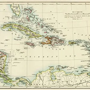
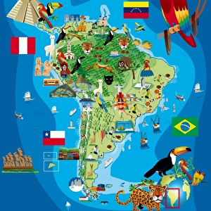
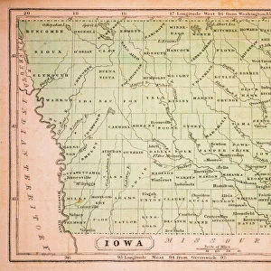
Glass Coaster : American ethnographic map


![]()
Home Decor from Fine Art Storehouse
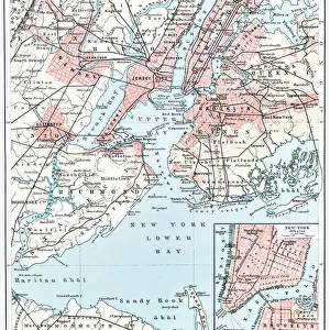
American ethnographic map
Illutration of American ethnographic map
Unleash your creativity and transform your space into a visual masterpiece!
Nastasic
Media ID 13591541
© This content is subject to copyright
Antarctica Arctic Argentina Atlantic Ocean Brazil Canada Cuba Direction Indian Ethnicity Indigenous Culture Mexican Ethnicity Mexico North America Pacific Ocean Peru Serbia South America Straits Ethnographic Retro Styled
Glass Coaster
Individual Glass Coaster. Stylish and elegant polished safety glass, toughened and heat resistant (10x10cm, 7mm thick). Price shown is per individual coaster.
Individual Glass Coaster. Elegant polished safety toughened glass and heat resistant, matching Place Mats are also available
Estimated Image Size (if not cropped) is 5.9cm x 7.6cm (2.3" x 3")
Estimated Product Size is 10cm x 10cm (3.9" x 3.9")
These are individually made so all sizes are approximate
Artwork printed orientated as per the preview above, with portrait (vertical) orientation to match the source image.
FEATURES IN THESE COLLECTIONS
> Fine Art Storehouse
> The Magical World of Illustration
> Nastasic Images & Illustrations
> Fine Art Storehouse
> Map
> Historical Maps
> Fine Art Storehouse
> Map
> USA Maps
> Arts
> Artists
> O
> Oceanic Oceanic
> Europe
> Serbia
> Related Images
> Maps and Charts
> Related Images
> North America
> Canada
> Maps
> North America
> Canada
> Related Images
> North America
> Cuba
> Maps
EDITORS COMMENTS
This print titled "American Ethnographic Map" takes us on a visual journey through the diverse cultures and rich history of the Americas. The retro-styled illustration, with its vibrant colors and intricate details, showcases the ethnicities that have shaped this vast continent. The vertical composition allows for a comprehensive view of North and South America, highlighting countries such as Mexico, USA, Argentina, Brazil, Peru, Canada, Cuba, and even extending to Serbia. The map encompasses not only land but also sea territories like the Arctic and Antarctic regions. With no people present in the image itself, our focus is solely on exploring indigenous cultures through transportation routes depicted by straits engraved on the map. This historical representation invites us to reflect upon how these communities thrived in harmony with their surroundings. The antique aesthetic adds an air of nostalgia to this studio-shot artwork. Its white background provides ample copy space for further exploration or personal interpretation. Whether you are a lover of travel or cartography enthusiast, this single object holds immense value as it encapsulates centuries of cultural exchange across continents. Overall, Nastasic's American Ethnographic Map serves as both an educational tool and a piece of art that celebrates diversity while honoring indigenous heritage within our shared human experience.
MADE IN THE UK
Safe Shipping with 30 Day Money Back Guarantee
FREE PERSONALISATION*
We are proud to offer a range of customisation features including Personalised Captions, Color Filters and Picture Zoom Tools
SECURE PAYMENTS
We happily accept a wide range of payment options so you can pay for the things you need in the way that is most convenient for you
* Options may vary by product and licensing agreement. Zoomed Pictures can be adjusted in the Basket.