Home > North America > United States of America > Maps
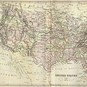
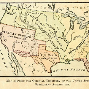
Map of United States 1876

![]()
Wall Art and Photo Gifts from Fine Art Storehouse
Map of United States 1876
Map of United States showing the territorial growth between 1780 and 1876
Unleash your creativity and transform your space into a visual masterpiece!
THEPALMER
Media ID 13613819
© Roberto A Sanchez
Atlantic Ocean Backgrounds Direction Grunge Grunge Image Technique North America Sepia Toned Obsolete
FEATURES IN THESE COLLECTIONS
> Fine Art Storehouse
> The Magical World of Illustration
> Palmer Illustrated Collection
> Fine Art Storehouse
> Map
> Historical Maps
> Fine Art Storehouse
> Map
> USA Maps
> Maps and Charts
> Early Maps
> Maps and Charts
> World
> North America
> United States of America
> Maps
EDITORS COMMENTS
This photo print, titled "Map of United States 1876" takes us on a journey through time, showcasing the territorial growth of the United States between 1780 and 1876. Created using the artful technique of engraving, this obsolete cartographic masterpiece offers a glimpse into America's past. The sepia-toned image exudes an air of nostalgia, transporting us back to an era when physical geography played a crucial role in shaping the nation. The intricate details etched onto this horizontal grunge map are awe-inspiring; every contour and boundary meticulously engraved by THEPALMER. As we explore this historical artifact, our eyes are drawn to the vastness of North America stretching from coast to coast. From the Atlantic Ocean to its western borders, each state is carefully demarcated with precision and accuracy. This map serves as a testament to America's expansion over nearly a century - from its humble beginnings as thirteen colonies striving for independence to becoming one unified nation. The absence of people in this photograph allows us to focus solely on the grandeur and significance of these territorial changes. It reminds us that history is not merely confined within textbooks but can be visually experienced through works like these. With its grunge image technique adding character and depth, this print would make an exceptional addition to any collection or space seeking a touch of vintage charm. Let it transport you back in time while igniting your curiosity about America's remarkable journey towards unity and progress.
MADE IN THE UK
Safe Shipping with 30 Day Money Back Guarantee
FREE PERSONALISATION*
We are proud to offer a range of customisation features including Personalised Captions, Color Filters and Picture Zoom Tools
SECURE PAYMENTS
We happily accept a wide range of payment options so you can pay for the things you need in the way that is most convenient for you
* Options may vary by product and licensing agreement. Zoomed Pictures can be adjusted in the Basket.