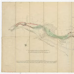
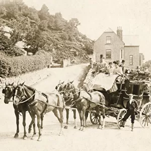
Framed Print : Plan of the Rivelin Valley from Rivelin Mill to Hollins Bridge, c. 1814


![]()
Framed Photos From Sheffield City Archives
Plan of the Rivelin Valley from Rivelin Mill to Hollins Bridge, c. 1814
From an original at Sheffield Libraries: arc03990.
Reading left to right: Rivelin Mill, [River Rivelin], Upper Coppice Wheel, Second Coppice Wheel, Third Coppice Wheel, paper mill, fourth coppice wheel, dam and works, Wolf Field, Wolf or Rocker, Wheel, J. Windle, George Harrop, Joseph Greaves, Rivelin South Bank Road, dam [ -] and works, Swallow Wheel, Robert Townsend, Thomas Burch, Rivelin North Bank Road, Jno. Brownell, Plonk Wheel, J. Harrison, Hind Wheels, Samuel Hallam, Upper Cutford Wheel, dam works and goight, Nether Cutford Wheel, Geo. Tippin, William Alsop, Little London Wheel, dam and works, Jno. Dale, Holmehead Wheel, Cadman, Spooner and Co. Mr Shaw, Roscoe Wheel, Works and dam and goight, Holme Wood, Threap Wood, Robert Greaves, Spooner Wheel, Rivelin Bridge Wheel, Thomas Blakes.
Shows [Rivelin Valley Road, Hagg Lane, Long Lane, Rivelin Park Road, Hollins Lane]
Sheffield City Archives and Local Studies Library has an unrivalled collection of images of Sheffield, England
Media ID 20665921
© Sheffield City Council - All Rights Reserved
22"x18" (58x48cm) Modern Frame
Step back in time with our exquisite framed print from Media Storehouse. This captivating piece showcases a historical Plan of the Rivelin Valley from Rivelin Mill to Hollins Bridge, dating back to approximately 1814. Originally sourced from Sheffield City Archives, this detailed illustration reveals the industrial landscape of the era, featuring Rivelin Mill, the River Rivelin, and several coppice wheels. Bring a touch of history into your home or office with this beautifully framed and preserved print, perfect for those who appreciate the rich heritage of Sheffield.
Wood effect frame, card mounted, 16x12 archival quality photo print. Overall outside dimensions 22x18 inches (58x48cm). Environmentally and ozone friendly, 40mm wide x 15mm Polycore® moulding has the look of real wood, is durable and light and easy to hang. Biodegradable and made with non-chlorinated gases (no toxic fumes) it is efficient; producing 100 tons of polystyrene can save 300 tons of trees! Prints are glazed with lightweight, shatterproof, optical clarity acrylic (providing the same general protection from the environment as glass). The back is stapled hardboard with a sawtooth hanger attached. Note: To minimise original artwork cropping, for optimum layout, and to ensure print is secure, the visible print may be marginally smaller
Contemporary Framed and Mounted Prints - Professionally Made and Ready to Hang
Estimated Image Size (if not cropped) is 39.6cm x 11.7cm (15.6" x 4.6")
Estimated Product Size is 57.9cm x 47.8cm (22.8" x 18.8")
These are individually made so all sizes are approximate
Artwork printed orientated as per the preview above, with landscape (horizontal) orientation to match the source image.
EDITORS COMMENTS
This print takes us back in time to the early 19th century, providing a detailed glimpse into the Rivelin Valley of Sheffield. The image showcases a meticulously drawn plan that spans from Rivelin Mill to Hollins Bridge, offering an invaluable historical record of this scenic landscape. As we follow the plan from left to right, our eyes are immediately drawn to the majestic Rivelin Mill standing proudly by the banks of River Rivelin. Moving along, we encounter a series of wheels and works that were vital for various industries during that era. Each wheel bears witness to the industrious activities taking place at Upper Coppice Wheel, Second Coppice Wheel, Third Coppice Wheel, and Fourth Coppice Wheel. The presence of paper mills further emphasizes the significance of this valley as a hub for manufacturing and production. We can also spot several names associated with these establishments such as J. Windle, George Harrop, Joseph Greaves - individuals who played crucial roles in shaping this industrial landscape. The plan not only highlights specific locations but also provides insight into transportation routes with mentions of roads like Rivelin South Bank Road and Rivelin North Bank Road. It is fascinating to observe how infrastructure was developed even during those times. Overall, this print serves as an invaluable historical artifact capturing both natural beauty and human ingenuity within Sheffield's renowned Rivelin Valley.
MADE IN THE UK
Safe Shipping with 30 Day Money Back Guarantee
FREE PERSONALISATION*
We are proud to offer a range of customisation features including Personalised Captions, Color Filters and Picture Zoom Tools
SECURE PAYMENTS
We happily accept a wide range of payment options so you can pay for the things you need in the way that is most convenient for you
* Options may vary by product and licensing agreement. Zoomed Pictures can be adjusted in the Basket.


![A map of the lands near Attercliffe and Darnall, [?1820s]](/sq/716/map-lands-near-attercliffe-darnall-1820s-18396317.jpg.webp)