Framed Print > Europe > United Kingdom > England > London > Museums > London Canal Museum
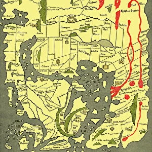
Framed Print : First geological map of Britain, 1815 C016 / 5683


![]()
Framed Photos from Science Photo Library
First geological map of Britain, 1815 C016 / 5683
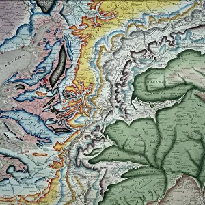
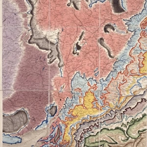
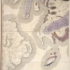
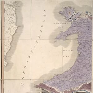
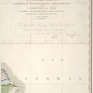
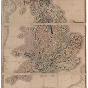
First geological map of Britain, detail of the north east coast (figure 8). This map was published in 1815 by British geologist William Smith (1769-1839). It shows rock layers (strata) in England and Wales and part of Scotland (key at lower left). Smiths work as a canal surveyor allowed him to study geology. He discovered that geological strata could be reliably identified at different places on the basis of the fossils they contained. Smith also proposed the principle of superposition, that if a strata overlays another then it was laid down at a later time. He is considered the father of English geology
Science Photo Library features Science and Medical images including photos and illustrations
Media ID 9206565
© NATURAL HISTORY MUSEUM, LONDON/SCIENCE PHOTO LIBRARY
1815 Cartography Coast Coastal Country Earth Science Geological Great Britain North East Pioneering Region Scottish Strata Stratigraphy Stratum Superposition Welsh William Smith
22"x18" (58x48cm) Modern Frame
Discover the rich history of geology with our stunning Framed Prints from Media Storehouse, featuring the First Geological Map of Britain, published in 1815 by the renowned British geologist, William Smith. This historic map, held in the Natural History Museum, London, and available through Science Photo Library, presents an intriguing glimpse into the early understanding of Britain's geological makeup. The detailed North East Coast section (figure 8) showcases the meticulous work that went into mapping the land, providing a fascinating piece of scientific history for your home or office. Add an element of intellectual sophistication and conversation-starting charm to any space with this captivating Framed Print.
Wood effect frame, card mounted, 16x12 archival quality photo print. Overall outside dimensions 22x18 inches (58x48cm). Environmentally and ozone friendly, 40mm wide x 15mm Polycore® moulding has the look of real wood, is durable and light and easy to hang. Biodegradable and made with non-chlorinated gases (no toxic fumes) it is efficient; producing 100 tons of polystyrene can save 300 tons of trees! Prints are glazed with lightweight, shatterproof, optical clarity acrylic (providing the same general protection from the environment as glass). The back is stapled hardboard with a sawtooth hanger attached. Note: To minimise original artwork cropping, for optimum layout, and to ensure print is secure, the visible print may be marginally smaller
Contemporary Framed and Mounted Prints - Professionally Made and Ready to Hang
Estimated Image Size (if not cropped) is 23.1cm x 39.6cm (9.1" x 15.6")
Estimated Product Size is 47.8cm x 57.9cm (18.8" x 22.8")
These are individually made so all sizes are approximate
Artwork printed orientated as per the preview above, with portrait (vertical) orientation to match the source image.
FEATURES IN THESE COLLECTIONS
> Asia
> East Timor
> Maps
> Asia
> East Timor
> Related Images
> Europe
> United Kingdom
> England
> London
> Museums
> British Library
> Europe
> United Kingdom
> England
> London
> Museums
> British Museum
> Europe
> United Kingdom
> England
> London
> Museums
> London Canal Museum
> Europe
> United Kingdom
> England
> London
> Museums
> Natural History Museum
> Europe
> United Kingdom
> England
> London
> Museums
> Science Museum
> Europe
> United Kingdom
> England
> London
> Sights
> British Museum
> Europe
> United Kingdom
> England
> London
> Sights
> London Canal Museum
> Europe
> United Kingdom
> England
> London
> Towns
> Lower Place
EDITORS COMMENTS
This print showcases the first geological map of Britain, a groundbreaking work published in 1815 by British geologist William Smith. The map, displayed here in detail of the north east coast (figure 8), provides a comprehensive depiction of rock layers (strata) found across England and Wales, as well as part of Scotland. William Smith's remarkable contribution to geology stemmed from his earlier career as a canal surveyor. Through his meticulous observations, he discovered that different geological strata could be reliably identified based on the fossils they contained. This revolutionary insight allowed for accurate mapping and understanding of Earth's history. Smith also proposed the principle of superposition, which states that if one layer overlays another, it was deposited at a later time. This concept became fundamental to stratigraphy and further solidified Smith's status as the father of English geology. The intricate illustration captures not only the geographical features but also includes a key at the lower left corner explaining various rock formations present in different regions. Its publication marked an important milestone in earth science and cartography during the early 19th century. Preserved by NATURAL HISTORY MUSEUM, LONDON/SCIENCE PHOTO LIBRARY, this artwork serves as an invaluable historical artifact showcasing pioneering research that laid the foundation for modern geological studies.
MADE IN THE UK
Safe Shipping with 30 Day Money Back Guarantee
FREE PERSONALISATION*
We are proud to offer a range of customisation features including Personalised Captions, Color Filters and Picture Zoom Tools
SECURE PAYMENTS
We happily accept a wide range of payment options so you can pay for the things you need in the way that is most convenient for you
* Options may vary by product and licensing agreement. Zoomed Pictures can be adjusted in the Basket.