Framed Print > Africa > Botswana > Maps
Framed Print : Map of Southern Africa


![]()
Framed Photos from Mary Evans Picture Library
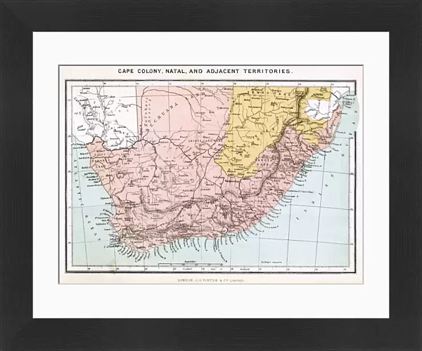
Map of Southern Africa
A map of Southern Africa, showing Natal and the Cape Colony. Date: 1885
Mary Evans Picture Library makes available wonderful images created for people to enjoy over the centuries
Media ID 20140929
© Bubblepunk
1885 Bechuanaland Botswana Cape Colonialism Colony Maps Natal Southern Territory Bechuana
14"x12" (38x32cm) Modern Frame
Discover the rich history and geography of Southern Africa with our stunning Framed Prints from Media Storehouse, featuring this captivating Map of Southern Africa from Mary Evans Prints Online. Dated 1885, this vintage map showcases the Cape Colony and Natal, offering a fascinating glimpse into the past. Each print is carefully framed in a contemporary style, adding an elegant touch to any room while transporting you on a journey through time. Bring the beauty of Southern Africa into your home or office with our Framed Prints, perfect for those who appreciate history and world culture.
Wood effect frame, card mounted, 10x8 archival quality photo print. Overall outside dimensions 14x12 inches (38x32cm). Environmentally and ozone friendly, 40mm wide x 15mm Polycore® moulding has the look of real wood, is durable and light and easy to hang. Biodegradable and made with non-chlorinated gases (no toxic fumes) it is efficient; producing 100 tons of polystyrene can save 300 tons of trees! Prints are glazed with lightweight, shatterproof, optical clarity acrylic (providing the same general protection from the environment as glass). The back is stapled hardboard with a sawtooth hanger attached. Note: To minimise original artwork cropping, for optimum layout, and to ensure print is secure, the visible print may be marginally smaller
Contemporary Framed and Mounted Prints - Professionally Made and Ready to Hang
Estimated Image Size (if not cropped) is 24.4cm x 17.5cm (9.6" x 6.9")
Estimated Product Size is 37.6cm x 32.5cm (14.8" x 12.8")
These are individually made so all sizes are approximate
Artwork printed orientated as per the preview above, with landscape (horizontal) orientation to match the source image.
FEATURES IN THESE COLLECTIONS
> Africa
> Botswana
> Related Images
> Africa
> Related Images
> Africa
> South Africa
> Maps
> Africa
> South Africa
> Related Images
> Maps and Charts
> Related Images
> Mary Evans Prints Online
> New Images July 2020
EDITORS COMMENTS
This map print, dating back to 1885, offers a glimpse into the geopolitical landscape of Southern Africa during the 1880s. The map meticulously delineates the territories of various European colonies and protectorates, including the prominent Natal and Cape Colony. At the time, European powers were aggressively expanding their territories in Africa, and this map reflects the growing influence of the British Empire in the region. The Cape Colony, established in 1652, is depicted in its expanded form, having annexed large swaths of land to the north and east. Natal, a British crown colony since 1845, is shown in the eastern part of the map, while the Bechuanaland Protectorate, later known as Botswana, is represented as a British territory to the north of the Cape Colony. The Bechuana people, also known as the Tswana, are the primary inhabitants of this region. The map also highlights other European territories, such as German South-West Africa (now Namibia) and Portuguese territories along the coast. The territorial claims and borders were not yet finalized, and the map serves as a testament to the dynamic and complex nature of colonialism in Southern Africa during the late 19th century. This map print is an essential historical document, providing valuable insights into the geopolitical landscape of Southern Africa during a pivotal period in its history. It offers a glimpse into the European powers' aggressive expansion and the impact of colonialism on the indigenous populations, shaping the political and demographic landscape of the region for generations to come.
MADE IN THE UK
Safe Shipping with 30 Day Money Back Guarantee
FREE PERSONALISATION*
We are proud to offer a range of customisation features including Personalised Captions, Color Filters and Picture Zoom Tools
SECURE PAYMENTS
We happily accept a wide range of payment options so you can pay for the things you need in the way that is most convenient for you
* Options may vary by product and licensing agreement. Zoomed Pictures can be adjusted in the Basket.