Framed Print > Europe > France > Canton > Landes
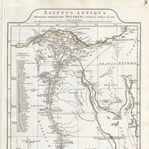
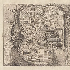
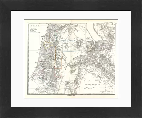
Framed Print : 1865, Spruner Map of Israel, Canaan, or Palestine in Ancient Times, topography, cartography


![]()
Framed Photos from Liszt Collection
1865, Spruner Map of Israel, Canaan, or Palestine in Ancient Times, topography, cartography
1865, Spruner Map of Israel, Canaan, or Palestine in Ancient Times
Liszt Collection of nineteenth-century engravings and images to browse and enjoy
Media ID 14006104
© Artokoloro Quint Lox Limited
Canaan Antique Map Latitude Longitude Mappa Mundi Old Antique Plan Old Antique View Ols Antique Map Rare Old Maps Topo
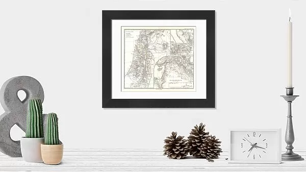
14"x12" (38x32cm) Modern Frame
Step back in time with our exquisite framed print from the Media Storehouse's Liszt Collection. This rare and captivating piece features the 1865 Spruner Map of Israel, Canaan, or Palestine in Ancient Times. Meticulously crafted with intricate topography and cartography, this vintage map offers a unique glimpse into the historical landscape of the region. Add an air of sophistication and intrigue to your home or office decor with this beautiful, museum-quality framed print. Each print is carefully inspected for quality and framed with archival materials to ensure longevity. Own a piece of history with the Media Storehouse's Framed Print of the 1865 Spruner Map of Israel, Canaan, or Palestine in Ancient Times.
Wood effect frame, card mounted, 10x8 archival quality photo print. Overall outside dimensions 14x12 inches (38x32cm). Environmentally and ozone friendly, 40mm wide x 15mm Polycore® moulding has the look of real wood, is durable and light and easy to hang. Biodegradable and made with non-chlorinated gases (no toxic fumes) it is efficient; producing 100 tons of polystyrene can save 300 tons of trees! Prints are glazed with lightweight, shatterproof, optical clarity acrylic (providing the same general protection from the environment as glass). The back is stapled hardboard with a sawtooth hanger attached. Note: To minimise original artwork cropping, for optimum layout, and to ensure print is secure, the visible print may be marginally smaller
Contemporary Framed and Mounted Prints - Professionally Made and Ready to Hang
Estimated Image Size (if not cropped) is 24.4cm x 20.4cm (9.6" x 8")
Estimated Product Size is 37.6cm x 32.5cm (14.8" x 12.8")
These are individually made so all sizes are approximate
Artwork printed orientated as per the preview above, with landscape (horizontal) orientation to match the source image.
FEATURES IN THESE COLLECTIONS
> Asia
> Israel
> Related Images
> Asia
> Palestine
> Related Images
> Europe
> France
> Canton
> Landes
> Historic
> Space exploration
> Maps and Charts
> Early Maps
> Maps and Charts
> Related Images
> Maps and Charts
> World
EDITORS COMMENTS
This print showcases the remarkable "1865, Spruner Map of Israel, Canaan, or Palestine in Ancient Times". A true masterpiece of topography and cartography, this vintage map takes us on a journey through history. With intricate detail and precision, it depicts the ancient land with its diverse geography and mesmerizing landscapes. The illustration is a testament to the artistry and skill of its creator. Every contour line meticulously drawn, every latitude and longitude carefully marked. It serves as a window into an era long gone but not forgotten. As we gaze upon this rare old map, we are transported back in time to an age of exploration and discovery. We can almost imagine ourselves traversing these ancient lands, uncovering their secrets and marveling at their beauty. The faded paper texture adds to the charm of this historical artifact. Its aged appearance only enhances our appreciation for the rich heritage it represents. This decorative piece would be a valuable addition to any collection or space dedicated to celebrating our world's past. Let this extraordinary map ignite your imagination as you delve into the wonders of ancient Israel, Canaan, or Palestine. May it serve as a reminder that even within old maps lie stories waiting to be discovered anew.
MADE IN THE UK
Safe Shipping with 30 Day Money Back Guarantee
FREE PERSONALISATION*
We are proud to offer a range of customisation features including Personalised Captions, Color Filters and Picture Zoom Tools
SECURE PAYMENTS
We happily accept a wide range of payment options so you can pay for the things you need in the way that is most convenient for you
* Options may vary by product and licensing agreement. Zoomed Pictures can be adjusted in the Basket.