Framed Print > Europe > United Kingdom > England > London > Sport > Sailing
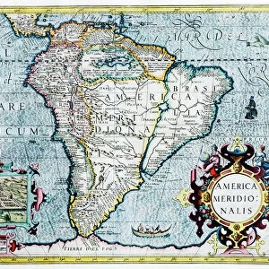
Framed Print : South America (America Meridionalis): from the Atlas of Gerardus Mercator, 1633, (1936). Artist: Gerardus Mercator
: from the Atlas of Gerardus Mercator, 1633, (1936). Artist: Gerardus Mercator")


: from the Atlas of Gerardus Mercator, 1633, (1936). Artist: Gerardus Mercator")


![]()
Framed Photos from Heritage Images
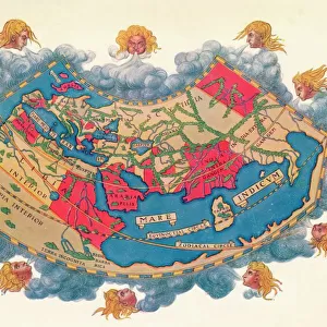
South America (America Meridionalis): from the Atlas of Gerardus Mercator, 1633, (1936). Artist: Gerardus Mercator
South America (America Meridionalis): from the Atlas of Gerardus Mercator, 1633, (1936). Published at Antwerp by Hondius From The Connoisseur, Vol. 98, edited by H. Granville Fell. [International Studio, London, 1936]
Heritage Images features heritage image collections
Media ID 14984985
© The Print Collector
Belgian Border Colourful Division Fell Gerardus H Granville H Granville Fell International Studio Latin Script Latin Text Mercator Navigation South American The Connoisseur Gerardus Mercator Inset
14"x12" (38x32cm) Modern Frame
Step back in time with our exquisite Framed Prints from the Media Storehouse collection. This captivating piece showcases the detailed and intriguing map of South America, titled "America Meridionalis," from the renowned Atlas of Gerardus Mercator, published in 1633. The map, reproduced from the original 1936 edition, is a masterpiece of cartography and historical art. Framed in a classic style, this print is not only an impressive addition to your home or office decor but also a conversation starter. Explore the rich history of cartography and geography with this stunning, vintage reproduction.
Wood effect frame, card mounted, 10x8 archival quality photo print. Overall outside dimensions 14x12 inches (38x32cm). Environmentally and ozone friendly, 40mm wide x 15mm Polycore® moulding has the look of real wood, is durable and light and easy to hang. Biodegradable and made with non-chlorinated gases (no toxic fumes) it is efficient; producing 100 tons of polystyrene can save 300 tons of trees! Prints are glazed with lightweight, shatterproof, optical clarity acrylic (providing the same general protection from the environment as glass). The back is stapled hardboard with a sawtooth hanger attached. Note: To minimise original artwork cropping, for optimum layout, and to ensure print is secure, the visible print may be marginally smaller
Contemporary Framed and Mounted Prints - Professionally Made and Ready to Hang
Estimated Image Size (if not cropped) is 24.4cm x 17.5cm (9.6" x 6.9")
Estimated Product Size is 37.6cm x 32.5cm (14.8" x 12.8")
These are individually made so all sizes are approximate
Artwork printed orientated as per the preview above, with landscape (horizontal) orientation to match the source image.
FEATURES IN THESE COLLECTIONS
> Animals
> Mammals
> Cricetidae
> Meridionalis
> Animals
> Mammals
> Sciuridae
> Meridionalis
> Arts
> Artists
> M
> Gerardus Mercator
> Arts
> Literature
> Magazines
> Europe
> Belgium
> Related Images
> Europe
> United Kingdom
> England
> London
> Sport
> Sailing
> Maps and Charts
> Gerardus Mercator's Cartographic
> Heritage Images
> Maps Charts & Plans
EDITORS COMMENTS
This print showcases a close-up view of South America, taken from the renowned Atlas of Gerardus Mercator in 1633. The print, published in Antwerp by Hondius and featured in The Connoisseur magazine, exudes a vibrant array of colors that bring the continent to life. With its rich hues and intricate detailing, this Belgian masterpiece captures the essence of South America's diverse landscapes and cultural heritage. The print is a testament to Mercator's exceptional cartographic skills as he meticulously delineates each country and border with precision. Latin script lettering adds an authentic touch to this seventeenth-century map, evoking a sense of historical significance. This piece serves as both an artistic creation and a navigational tool for sailors during that era. As we gaze upon this remarkable image, we are transported back to the thirties - a time when exploration was at its peak. The publication itself represents an intersection between centuries; merging elements from the seventeenth century with those of twentieth-century design. With its detailed inset maps and informative text, this print offers viewers not only visual pleasure but also valuable insights into South America's geography and topography. It stands as a testament to Mercator's enduring legacy as one of history's most influential cartographers.
MADE IN THE UK
Safe Shipping with 30 Day Money Back Guarantee
FREE PERSONALISATION*
We are proud to offer a range of customisation features including Personalised Captions, Color Filters and Picture Zoom Tools
SECURE PAYMENTS
We happily accept a wide range of payment options so you can pay for the things you need in the way that is most convenient for you
* Options may vary by product and licensing agreement. Zoomed Pictures can be adjusted in the Basket.