Framed Print > Fine Art Storehouse > Map
Framed Print : Antique Map of the World


![]()
Framed Photos from Fine Art Storehouse
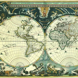
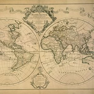
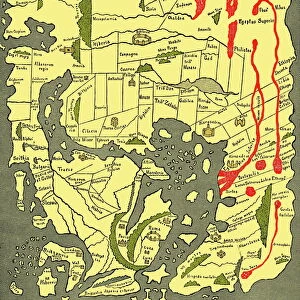
Antique Map of the World
Vintage map of the World from 1884
Unleash your creativity and transform your space into a visual masterpiece!
duncan1890
Media ID 13666647
© duncan1890
1880 1889 Asia Pac Chart Globe Globe Navigational Equipment Image Created 1880 1889 Manufactured Object Navigational Equipment North America Objects Equipment Past South America Styles The Americas Travel Locations World Map Image Created 19th Century Obsolete Victorian Style
14"x12" (38x32cm) Modern Frame
Step back in time with our Antique Map of the World Framed Print from the Media Storehouse Fine Art Collection. This stunning vintage map, created by duncan1890 in 1884, beautifully captures the world as it was known over a century ago. The intricate details and rich colors of this historical masterpiece are brought to life in our high-quality framed print, making it a captivating addition to any room in your home or office. Transport yourself to a bygone era with this unique and fascinating piece of decor. Order now and let history come alive in your space.
Wood effect frame, card mounted, 10x8 archival quality photo print. Overall outside dimensions 14x12 inches (38x32cm). Environmentally and ozone friendly, 40mm wide x 15mm Polycore® moulding has the look of real wood, is durable and light and easy to hang. Biodegradable and made with non-chlorinated gases (no toxic fumes) it is efficient; producing 100 tons of polystyrene can save 300 tons of trees! Prints are glazed with lightweight, shatterproof, optical clarity acrylic (providing the same general protection from the environment as glass). The back is stapled hardboard with a sawtooth hanger attached. Note: To minimise original artwork cropping, for optimum layout, and to ensure print is secure, the visible print may be marginally smaller
Contemporary Framed and Mounted Prints - Professionally Made and Ready to Hang
Estimated Image Size (if not cropped) is 24.4cm x 18.6cm (9.6" x 7.3")
Estimated Product Size is 37.6cm x 32.5cm (14.8" x 12.8")
These are individually made so all sizes are approximate
Artwork printed orientated as per the preview above, with landscape (horizontal) orientation to match the source image.
FEATURES IN THESE COLLECTIONS
> Fine Art Storehouse
> Map
> Historical Maps
EDITORS COMMENTS
This print titled "Antique Map of the World" takes us on a journey back in time to the 19th century. Created in 1884, this vintage map showcases the artistry and precision of cartography during that era. The intricate engravings and obsolete navigational equipment depicted on this image transport us to a world where exploration and discovery were at their peak. The Victorian style of this map adds an air of elegance and sophistication, reflecting the tastes and sensibilities of that period. With Asia, Europe, Africa, North America, South America, and the Americas beautifully illustrated across its horizontal layout, it serves as a visual testament to our planet's rich history. As we gaze upon this piece from Duncan1890's collection, we are reminded of how far we have come in terms of technology and knowledge about our world. It sparks curiosity about past travel locations while also serving as a reminder that even though times change rapidly, there is always something valuable to learn from the past. With no people present within its frame, this antique map invites us to explore on our own terms. Its presence evokes feelings of nostalgia for a bygone era when maps were cherished objects used for both practical navigation and aesthetic appreciation. In summary, "Antique Map of the World" by duncan1890 is not just an image; it is a portal into history - an exquisite representation of 19th-century cartography that captivates viewers with its beauty and historical significance.
MADE IN THE UK
Safe Shipping with 30 Day Money Back Guarantee
FREE PERSONALISATION*
We are proud to offer a range of customisation features including Personalised Captions, Color Filters and Picture Zoom Tools
SECURE PAYMENTS
We happily accept a wide range of payment options so you can pay for the things you need in the way that is most convenient for you
* Options may vary by product and licensing agreement. Zoomed Pictures can be adjusted in the Basket.