Fine Art Print > Fine Art Storehouse > Map
Fine Art Print : Antique Map of the World


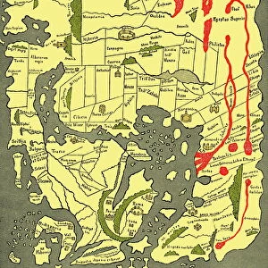
![]()
Fine Art Prints from Fine Art Storehouse
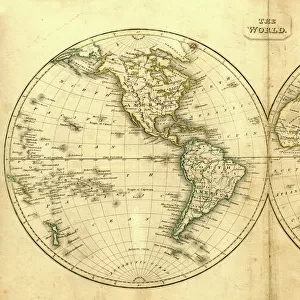
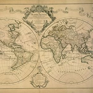
Antique Map of the World
Vintage map of the World from 1884
Unleash your creativity and transform your space into a visual masterpiece!
duncan1890
Media ID 13666647
© duncan1890
1880 1889 Asia Pac Chart Globe Globe Navigational Equipment Image Created 1880 1889 Manufactured Object Navigational Equipment North America Objects Equipment Past South America Styles The Americas Travel Locations World Map Image Created 19th Century Obsolete Victorian Style
A2 (42x59cm) Fine Art Print
Step back in time with our exquisite Antique Map of the World by duncan1890 from the Media Storehouse Fine Art Prints collection. This vintage masterpiece, dated 1884, transports you to a bygone era with its intricate details and captivating design. Add an air of sophistication and historical charm to your space with this beautiful work of art. Printed on high-quality archival paper for long-lasting vibrancy and detail, this Fine Art Print is a must-have for history enthusiasts and collectors alike.
Our Fine Art Prints are printed on 100% acid free, PH neutral paper with archival properties. This printing method is used by museums and art collections to exhibit photographs and art reproductions. Hahnemühle certified studio for digital fine art printing. Printed on 308gsm Photo Rag Paper.
Our fine art prints are high-quality prints made using a paper called Photo Rag. This 100% cotton rag fibre paper is known for its exceptional image sharpness, rich colors, and high level of detail, making it a popular choice for professional photographers and artists. Photo rag paper is our clear recommendation for a fine art paper print. If you can afford to spend more on a higher quality paper, then Photo Rag is our clear recommendation for a fine art paper print.
Estimated Image Size (if not cropped) is 55cm x 42cm (21.7" x 16.5")
Estimated Product Size is 59.4cm x 42cm (23.4" x 16.5")
These are individually made so all sizes are approximate
Artwork printed orientated as per the preview above, with landscape (horizontal) orientation to match the source image.
FEATURES IN THESE COLLECTIONS
> Fine Art Storehouse
> Map
> Historical Maps
EDITORS COMMENTS
This print titled "Antique Map of the World" takes us on a journey back in time to the 19th century. Created in 1884, this vintage map showcases the artistry and precision of cartography during that era. The intricate engravings and obsolete navigational equipment depicted on this image transport us to a world where exploration and discovery were at their peak. The Victorian style of this map adds an air of elegance and sophistication, reflecting the tastes and sensibilities of that period. With Asia, Europe, Africa, North America, South America, and the Americas beautifully illustrated across its horizontal layout, it serves as a visual testament to our planet's rich history. As we gaze upon this piece from Duncan1890's collection, we are reminded of how far we have come in terms of technology and knowledge about our world. It sparks curiosity about past travel locations while also serving as a reminder that even though times change rapidly, there is always something valuable to learn from the past. With no people present within its frame, this antique map invites us to explore on our own terms. Its presence evokes feelings of nostalgia for a bygone era when maps were cherished objects used for both practical navigation and aesthetic appreciation. In summary, "Antique Map of the World" by duncan1890 is not just an image; it is a portal into history - an exquisite representation of 19th-century cartography that captivates viewers with its beauty and historical significance.
MADE IN THE UK
Safe Shipping with 30 Day Money Back Guarantee
FREE PERSONALISATION*
We are proud to offer a range of customisation features including Personalised Captions, Color Filters and Picture Zoom Tools
SECURE PAYMENTS
We happily accept a wide range of payment options so you can pay for the things you need in the way that is most convenient for you
* Options may vary by product and licensing agreement. Zoomed Pictures can be adjusted in the Basket.