Framed Print > Europe > United Kingdom > England > Greater Manchester > Manchester
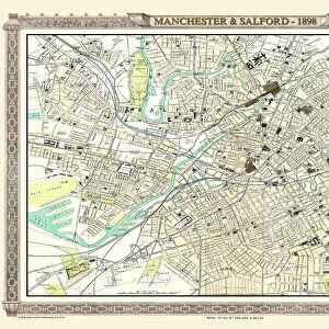
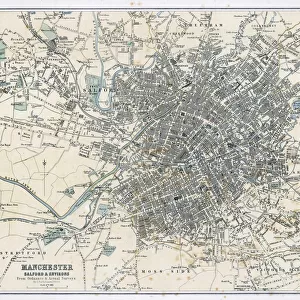
Framed Print : Antique map, Manchester, England, 19th Century


![]()
Framed Photos from Fine Art Storehouse
Antique map, Manchester, England, 19th Century
Vintage engraving of a Antique map, Manchester, England, 19th Century
Unleash your creativity and transform your space into a visual masterpiece!
duncan1890
Media ID 15107367
© This content is subject to copyright
1890s Colour Colours Equipment Great Britain Image Created 1890 1899 Manchester Navigational Equipment North West England Northern Europe Retro Road Map Styles Supplies United Kingdom Victorian Greater Manchester Obsolete
14"x12" (38x32cm) Modern Frame
Step back in time with our exquisite Framed Print of an Antique Map of Manchester, England, from the 19th Century. Meticulously crafted by the talented artist duncan1890 from the Fine Art Storehouse, this Vintage Engraving transports you to a bygone era. The intricate details of the map's topography and geography are sure to captivate history enthusiasts and art lovers alike. Add an air of sophistication and character to your home or office with this beautiful, authentic piece of history.
Wood effect frame, card mounted, 10x8 archival quality photo print. Overall outside dimensions 14x12 inches (38x32cm). Environmentally and ozone friendly, 40mm wide x 15mm Polycore® moulding has the look of real wood, is durable and light and easy to hang. Biodegradable and made with non-chlorinated gases (no toxic fumes) it is efficient; producing 100 tons of polystyrene can save 300 tons of trees! Prints are glazed with lightweight, shatterproof, optical clarity acrylic (providing the same general protection from the environment as glass). The back is stapled hardboard with a sawtooth hanger attached. Note: To minimise original artwork cropping, for optimum layout, and to ensure print is secure, the visible print may be marginally smaller
Contemporary Framed and Mounted Prints - Professionally Made and Ready to Hang
Estimated Image Size (if not cropped) is 19.5cm x 24.4cm (7.7" x 9.6")
Estimated Product Size is 32.5cm x 37.6cm (12.8" x 14.8")
These are individually made so all sizes are approximate
Artwork printed orientated as per the preview above, with portrait (vertical) orientation to match the source image.
FEATURES IN THESE COLLECTIONS
> Fine Art Storehouse
> Map
> Historical Maps
> Europe
> Related Images
> Europe
> United Kingdom
> England
> Greater Manchester
> Manchester
> Europe
> United Kingdom
> England
> Manchester
> Manchester
> Europe
> United Kingdom
> England
> Maps
> Europe
> United Kingdom
> England
> Paintings
> Europe
> United Kingdom
> England
> Posters
> Europe
> United Kingdom
> England
> Related Images
> Europe
> United Kingdom
> Related Images
> Historic
> Historical fashion trends
> Victorian fashion trends
> Historic
> Victorian era fashion
EDITORS COMMENTS
This vintage engraving takes us back in time to the 19th century, showcasing an antique map of Manchester, England. The intricate details and vibrant colors bring this piece of cartography to life, revealing a snapshot of history that is both fascinating and nostalgic. The map itself was created in the 1890s, offering a glimpse into the past when navigational equipment was still rudimentary and road maps were essential for travelers. It captures the essence of Victorian England with its old-fashioned charm and elegant style. As we study this lithograph closely, we can appreciate the artistry involved in its creation. The careful engravings depict every street and landmark with precision, providing a visual guide to Greater Manchester and its surroundings. This print serves as a testament to the craftsmanship of yesteryears' illustrators who meticulously crafted such detailed images. Transporting us back to Northern Europe during this bygone era, it allows us to reflect on how much has changed since then. With modern technology rendering these types of maps obsolete today, this print becomes even more valuable as a historical artifact. Duncan1890's photograph perfectly captures all these elements - from the faded colors that evoke nostalgia for times gone by to the delicate lines that tell stories untold. It invites viewers on a journey through time while appreciating Manchester's rich history within their own homes or offices.
MADE IN THE UK
Safe Shipping with 30 Day Money Back Guarantee
FREE PERSONALISATION*
We are proud to offer a range of customisation features including Personalised Captions, Color Filters and Picture Zoom Tools
SECURE PAYMENTS
We happily accept a wide range of payment options so you can pay for the things you need in the way that is most convenient for you
* Options may vary by product and licensing agreement. Zoomed Pictures can be adjusted in the Basket.