Home > Europe > United Kingdom > England > Manchester > Manchester
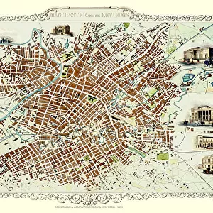
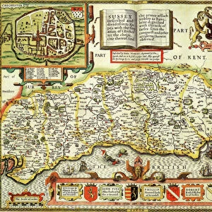
Map of Manchester, 1751 (engraving)
")
![]()
Wall Art and Photo Gifts from Fine Art Finder
Map of Manchester, 1751 (engraving)
XJF466271 Map of Manchester, 1751 (engraving) by Casson & Berry (fl.1750); Private Collection; (add.info.: image also shows a panorama of the city, as well as an view of St. Anns Square, and the interior of the Manchester Long Room; ); English, out of copyright
Media ID 12808899
© www.bridgemanart.com
FEATURES IN THESE COLLECTIONS
> Arts
> Artists
> Related Images
> Europe
> United Kingdom
> England
> Manchester
> Manchester
EDITORS COMMENTS
This print showcases a remarkable piece of history - the "Map of Manchester, 1751". Engraved by Casson & Berry, this exquisite artwork takes us back in time to the bustling cityscape of Manchester during the 18th century. The map not only provides a detailed layout of the city but also offers a panoramic view that allows us to immerse ourselves in its vibrant atmosphere. From St. Anns Square, with its charming architecture and lively streets, to the interior of the magnificent Manchester Long Room, every element depicted on this engraving tells a story. As we explore this visual treasure trove, it becomes evident that this map was meticulously crafted with great attention to detail. Every street and building is intricately illustrated, giving us an insight into how Manchester looked over two centuries ago. This print from Fine Art Finder captures not just a mere representation of an old map; it encapsulates an entire era's essence within its frame. It invites us to reflect upon how much has changed since then while marveling at the enduring spirit and growth of one of England's most iconic cities. Whether you are an art enthusiast or simply intrigued by history, this image will transport you back in time and allow you to appreciate both the beauty and significance behind this historical masterpiece.
MADE IN THE UK
Safe Shipping with 30 Day Money Back Guarantee
FREE PERSONALISATION*
We are proud to offer a range of customisation features including Personalised Captions, Color Filters and Picture Zoom Tools
SECURE PAYMENTS
We happily accept a wide range of payment options so you can pay for the things you need in the way that is most convenient for you
* Options may vary by product and licensing agreement. Zoomed Pictures can be adjusted in the Basket.