Framed Print > Fine Art Storehouse > Map
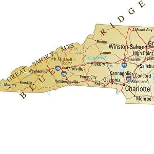
Framed Print : Virginia North Carolina map 1881


![]()
Framed Photos from Fine Art Storehouse
Virginia North Carolina map 1881
Coltons Common School Geography 1881 New York Sheldon and Co
Unleash your creativity and transform your space into a visual masterpiece!
THEPALMER
Media ID 13669265
© This content is subject to copyright
American Culture Globe Navigational Equipment Maryland State North America North Carolina Us State Paper Planet Earth South Carolina Virginia Us State World Map
14"x12" (38x32cm) Modern Frame
Step back in time with our exquisite Framed Print of the "Virginia North Carolina Map 1881" by THEPALMER from our Media Storehouse collection. This vintage map, originally published by Colton's Common School Geography 1881 New York Sheldon and Co, is a beautiful addition to any home or office. The intricate details of the map are sure to captivate and transport you back to a bygone era. Framed in a classic design, this print makes for a stunning conversation piece. Bring a piece of historical cartography into your space and add a touch of timeless charm to your decor. Order yours today!
Wood effect frame, card mounted, 10x8 archival quality photo print. Overall outside dimensions 14x12 inches (38x32cm). Environmentally and ozone friendly, 40mm wide x 15mm Polycore® moulding has the look of real wood, is durable and light and easy to hang. Biodegradable and made with non-chlorinated gases (no toxic fumes) it is efficient; producing 100 tons of polystyrene can save 300 tons of trees! Prints are glazed with lightweight, shatterproof, optical clarity acrylic (providing the same general protection from the environment as glass). The back is stapled hardboard with a sawtooth hanger attached. Note: To minimise original artwork cropping, for optimum layout, and to ensure print is secure, the visible print may be marginally smaller
Contemporary Framed and Mounted Prints - Professionally Made and Ready to Hang
Estimated Image Size (if not cropped) is 20.3cm x 24.4cm (8" x 9.6")
Estimated Product Size is 32.5cm x 37.6cm (12.8" x 14.8")
These are individually made so all sizes are approximate
Artwork printed orientated as per the preview above, with portrait (vertical) orientation to match the source image.
FEATURES IN THESE COLLECTIONS
> Fine Art Storehouse
> The Magical World of Illustration
> Palmer Illustrated Collection
> Fine Art Storehouse
> Map
> Historical Maps
> Fine Art Storehouse
> Map
> USA Maps
EDITORS COMMENTS
This vintage map print of Virginia and North Carolina from 1881 takes us back in time to an era when cartography was a true art form. The intricate details engraved on the paper showcase the remarkable craftsmanship that went into creating this piece. As we gaze upon this historical artifact, we are transported to a bygone era, where explorers relied on maps like these to navigate the vast landscapes of North America. The map not only highlights the borders of Virginia and North Carolina but also provides a glimpse into neighboring states such as Maryland, South Carolina, and West Virginia. It serves as a reminder of how interconnected these regions were during that period. Beyond its navigational purpose, this antique map offers valuable insights into American culture and physical geography at the time. Its illustrations depict various geographical features, giving us a sense of the diverse terrain found across these states. From mountains to rivers and coastlines, it showcases the natural beauty that has shaped these regions for centuries. As we admire this timeless piece of history, let us appreciate both its artistic value and its significance in understanding our past. This print is not just an image; it represents an entire era's perspective on our planet Earth—a testament to human curiosity and exploration throughout history.
MADE IN THE UK
Safe Shipping with 30 Day Money Back Guarantee
FREE PERSONALISATION*
We are proud to offer a range of customisation features including Personalised Captions, Color Filters and Picture Zoom Tools
SECURE PAYMENTS
We happily accept a wide range of payment options so you can pay for the things you need in the way that is most convenient for you
* Options may vary by product and licensing agreement. Zoomed Pictures can be adjusted in the Basket.