Fine Art Print > Fine Art Storehouse > Map
Fine Art Print : Virginia North Carolina map 1881


![]()
Fine Art Prints from Fine Art Storehouse
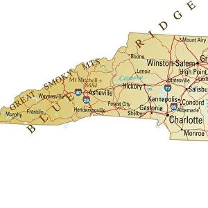
Virginia North Carolina map 1881
Coltons Common School Geography 1881 New York Sheldon and Co
Unleash your creativity and transform your space into a visual masterpiece!
THEPALMER
Media ID 13669265
© This content is subject to copyright
American Culture Globe Navigational Equipment Maryland State North America North Carolina Us State Paper Planet Earth South Carolina Virginia Us State World Map
A2 (42x59cm) Fine Art Print
Step back in time with this exquisite Virginia North Carolina map from ThePalmer, part of our Fine Art Prints collection at Media Storehouse. Originally published in Colton's Common School Geography by Sheldon and Co, New York in 1881, this vintage map offers a captivating glimpse into the history and geography of the Old Dominion State. With intricate detail and beautiful antique cartography, this print makes a stunning addition to any home or office, transporting you to a bygone era. Bring history to life with this unique and captivating piece from Media Storehouse.
Our Fine Art Prints are printed on 100% acid free, PH neutral paper with archival properties. This printing method is used by museums and art collections to exhibit photographs and art reproductions. Hahnemühle certified studio for digital fine art printing. Printed on 308gsm Photo Rag Paper.
Our fine art prints are high-quality prints made using a paper called Photo Rag. This 100% cotton rag fibre paper is known for its exceptional image sharpness, rich colors, and high level of detail, making it a popular choice for professional photographers and artists. Photo rag paper is our clear recommendation for a fine art paper print. If you can afford to spend more on a higher quality paper, then Photo Rag is our clear recommendation for a fine art paper print.
Estimated Image Size (if not cropped) is 42cm x 50.6cm (16.5" x 19.9")
Estimated Product Size is 42cm x 59.4cm (16.5" x 23.4")
These are individually made so all sizes are approximate
Artwork printed orientated as per the preview above, with portrait (vertical) orientation to match the source image.
FEATURES IN THESE COLLECTIONS
> Fine Art Storehouse
> The Magical World of Illustration
> Palmer Illustrated Collection
> Fine Art Storehouse
> Map
> Historical Maps
> Fine Art Storehouse
> Map
> USA Maps
EDITORS COMMENTS
This vintage map print of Virginia and North Carolina from 1881 takes us back in time to an era when cartography was a true art form. The intricate details engraved on the paper showcase the remarkable craftsmanship that went into creating this piece. As we gaze upon this historical artifact, we are transported to a bygone era, where explorers relied on maps like these to navigate the vast landscapes of North America. The map not only highlights the borders of Virginia and North Carolina but also provides a glimpse into neighboring states such as Maryland, South Carolina, and West Virginia. It serves as a reminder of how interconnected these regions were during that period. Beyond its navigational purpose, this antique map offers valuable insights into American culture and physical geography at the time. Its illustrations depict various geographical features, giving us a sense of the diverse terrain found across these states. From mountains to rivers and coastlines, it showcases the natural beauty that has shaped these regions for centuries. As we admire this timeless piece of history, let us appreciate both its artistic value and its significance in understanding our past. This print is not just an image; it represents an entire era's perspective on our planet Earth—a testament to human curiosity and exploration throughout history.
MADE IN THE UK
Safe Shipping with 30 Day Money Back Guarantee
FREE PERSONALISATION*
We are proud to offer a range of customisation features including Personalised Captions, Color Filters and Picture Zoom Tools
SECURE PAYMENTS
We happily accept a wide range of payment options so you can pay for the things you need in the way that is most convenient for you
* Options may vary by product and licensing agreement. Zoomed Pictures can be adjusted in the Basket.