Framed Print > North America > United States of America > Virginia > Chesapeake
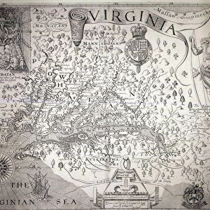
Framed Print : Map of Virginia, discovered and described by Captain John Smith, 1606


![]()
Framed Photos From Fine Art Finder
Map of Virginia, discovered and described by Captain John Smith, 1606
STC174211 Map of Virginia, discovered and described by Captain John Smith, 1606, engraved by William Hole (fl. 1607-24), published 1612 (engraving) (see also 174212) by Smith, John (1580-1631) (after); Private Collection; (add.info.: John Smith went to Virginia with first settlers 1606; Captured by Powhatan, Chief of Algonquian tribes of Powhatan Confederation 1607 (see top left); saved by Pocahontas, daughter of Powhatan; ); The Stapleton Collection; English, out of copyright
Media ID 23355242
© The Stapleton Collection / Bridgeman Images
Cartographer Chesapeake Bay Jamestown Susquehanna Tribe Mapped
14"x12" (38x32cm) Modern Frame
Bring the rich history of Virginia to your home or office with our stunning Framed Prints featuring the iconic Map of Virginia, discovered and described by Captain John Smith in 1606. This intricately detailed map, engraved by William Hole and published in 1612, offers a fascinating glimpse into the early exploration of the New World. The vivid colors and crisp lines of this Fine Art Finder exclusive from Bridgeman Images are sure to captivate and inspire, making this a must-have addition to any collection. Order your Framed Print today and transport yourself back in time.
Wood effect frame, card mounted, 10x8 archival quality photo print. Overall outside dimensions 14x12 inches (38x32cm). Environmentally and ozone friendly, 40mm wide x 15mm Polycore® moulding has the look of real wood, is durable and light and easy to hang. Biodegradable and made with non-chlorinated gases (no toxic fumes) it is efficient; producing 100 tons of polystyrene can save 300 tons of trees! Prints are glazed with lightweight, shatterproof, optical clarity acrylic (providing the same general protection from the environment as glass). The back is stapled hardboard with a sawtooth hanger attached. Note: To minimise original artwork cropping, for optimum layout, and to ensure print is secure, the visible print may be marginally smaller
Contemporary Framed and Mounted Prints - Professionally Made and Ready to Hang
Estimated Image Size (if not cropped) is 24.4cm x 19.6cm (9.6" x 7.7")
Estimated Product Size is 37.6cm x 32.5cm (14.8" x 12.8")
These are individually made so all sizes are approximate
Artwork printed orientated as per the preview above, with landscape (horizontal) orientation to match the source image.
FEATURES IN THESE COLLECTIONS
> Fine Art Finder
> Artists
> French School
> Fine Art Finder
> Artists
> John (after) Smith
> Fine Art Finder
> Maps (celestial & Terrestrial)
> Arts
> Artists
> H
> William Hole
> Maps and Charts
> Related Images
> North America
> United States of America
> Virginia
> Chesapeake
EDITORS COMMENTS
This print showcases the historic "Map of Virginia, discovered and described by Captain John Smith" from 1606. Engraved by William Hole and published in 1612, this intricate map provides a fascinating glimpse into the early exploration of America. Captain John Smith, an English cartographer and adventurer, embarked on a journey to Virginia with the first settlers in 1606. The map depicts his remarkable encounters with the native tribes of the region, including a depiction of Powhatan, Chief of Algonquian tribes who captured Smith in 1607. However, it was Pocahontas, Powhatan's daughter, who famously saved Smith from execution. This pivotal moment is symbolized in the top left corner of the map - a testament to their extraordinary encounter. The Map of Virginia not only offers geographical details but also serves as an invaluable historical document showcasing early colonial life at Jamestown and its surroundings. It beautifully captures both land and sea features such as Chesapeake Bay and Susquehanna River. As we delve into this print from Fine Art Finder's private collection, we are transported back to a time when exploration was filled with wonderment and danger. It reminds us that history is shaped by individuals like Captain John Smith who ventured into unknown territories to expand our understanding of the world around us.
MADE IN THE UK
Safe Shipping with 30 Day Money Back Guarantee
FREE PERSONALISATION*
We are proud to offer a range of customisation features including Personalised Captions, Color Filters and Picture Zoom Tools
SECURE PAYMENTS
We happily accept a wide range of payment options so you can pay for the things you need in the way that is most convenient for you
* Options may vary by product and licensing agreement. Zoomed Pictures can be adjusted in the Basket.