Framed Print > Africa > The Gambia > Maps
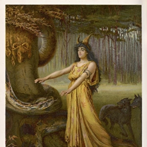
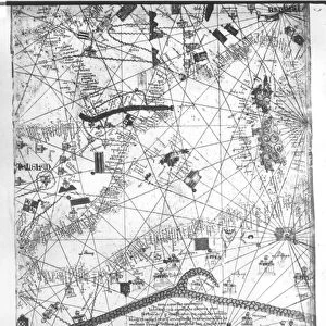
Framed Print : Catalan Atlas, Sheet 6, 1375 (pen with coloured inks on parchment)
")
")


![]()
Framed Photos from Fine Art Finder
Catalan Atlas, Sheet 6, 1375 (pen with coloured inks on parchment)
5054638 Catalan Atlas, Sheet 6, 1375 (pen with coloured inks on parchment) by Cresques, Abraham (1325-87); Bibliotheque Nationale, Paris, France; (add.info.: World map made in Majorca, with Jerusalem close to the centre, attributed to a Jewish cartographer in the service of the king of Aragon, covers an area from the Atlantic to China, from Scandinavia to the Rio Oro in Africa. The King of Mali, " Musse Melly" (Mansa Musa) holds a sceptre with a fleur-de-lys and a golden disc. He was known to control a large part of Africa, from Gambia and Senegal to Gao on the Niger, and had access to some of its richest gold deposits.); Spanish, out of copyright
Media ID 23258888
© Bridgeman Images
Atlas Camel Catalan Catalan Atlas Catalonia Compass Compass Lines Cosmography Early Map Hydrography Majorcan Mansa Musa Mappa Mundi Mediterranean Nautical Nautical Charts Navigation Navigational Portolan Sea Chart Silk Road Spice Trade Spices Vellum World Map
22"x18" (58x48cm) Modern Frame
Discover the rich history and intricate detail of the Catalan Atlas with our Framed Prints from Media Storehouse. This stunning reproduction showcases Sheet 6, 1375, featuring a beautiful world map created by Abraham Cresques using pen with coloured inks on parchment. Originally housed in the Bibliotheque Nationale in Paris, France, this rare and precious artifact is now available to adorn your home or office. Bring a piece of history into your space with our high-quality Framed Prints.
Wood effect frame, card mounted, 16x12 archival quality photo print. Overall outside dimensions 22x18 inches (58x48cm). Environmentally and ozone friendly, 40mm wide x 15mm Polycore® moulding has the look of real wood, is durable and light and easy to hang. Biodegradable and made with non-chlorinated gases (no toxic fumes) it is efficient; producing 100 tons of polystyrene can save 300 tons of trees! Prints are glazed with lightweight, shatterproof, optical clarity acrylic (providing the same general protection from the environment as glass). The back is stapled hardboard with a sawtooth hanger attached. Note: To minimise original artwork cropping, for optimum layout, and to ensure print is secure, the visible print may be marginally smaller
Contemporary Framed and Mounted Prints - Professionally Made and Ready to Hang
Estimated Image Size (if not cropped) is 16.2cm x 39.6cm (6.4" x 15.6")
Estimated Product Size is 47.8cm x 57.9cm (18.8" x 22.8")
These are individually made so all sizes are approximate
Artwork printed orientated as per the preview above, with portrait (vertical) orientation to match the source image.
FEATURES IN THESE COLLECTIONS
> Fine Art Finder
> Artists
> Abraham Cresques
> Africa
> The Gambia
> Maps
> Africa
> Mali
> Related Images
> Africa
> Niger
> Related Images
> Africa
> Related Images
> Africa
> Senegal
> Related Images
> Animals
> Mammals
> Cricetidae
> Golden Mouse
EDITORS COMMENTS
This print showcases the Catalan Atlas, Sheet 6, created in 1375 by Abraham Cresques. Crafted with pen and colored inks on parchment, this world map was made in Majorca and is now housed at the Bibliotheque Nationale in Paris, France. The map covers a vast area from the Atlantic to China, Scandinavia to the Rio Oro in Africa. What makes this map truly remarkable is its attribution to a Jewish cartographer serving the king of Aragon. It features Jerusalem near the center and offers a unique perspective on global geography during that time period. One notable figure depicted on this map is Mansa Musa, also known as "Musse Melly" who controlled a significant portion of Africa's riches including gold deposits from Gambia and Senegal to Gao on the Niger River. Holding a scepter adorned with a fleur-de-lys and golden disc, Mansa Musa symbolizes his power and wealth. The Catalan Atlas serves as an invaluable historical artifact providing insights into medieval trade routes such as the Silk Road and maritime exploration. Its intricate details include nautical charts, compass lines for navigation purposes, coastal outlines of various regions including Europe and North Africa. This print allows us to appreciate not only the artistry but also the significance of early cartography in shaping our understanding of world history.
MADE IN THE UK
Safe Shipping with 30 Day Money Back Guarantee
FREE PERSONALISATION*
We are proud to offer a range of customisation features including Personalised Captions, Color Filters and Picture Zoom Tools
SECURE PAYMENTS
We happily accept a wide range of payment options so you can pay for the things you need in the way that is most convenient for you
* Options may vary by product and licensing agreement. Zoomed Pictures can be adjusted in the Basket.