Fine Art Print > Europe > France > Canton > Ille
Fine Art Print : Departement of Ille-et-Vilaine, France, Relief Map


![]()
Fine Art Prints from Universal Images Group (UIG)
Departement of Ille-et-Vilaine, France, Relief Map
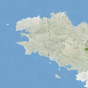
Relief map of the departement of Ille-et-Vilaine, France. It is bordered by the English Channel to the north. This image was compiled from data acquired by LANDSAT 5 & 7 satellites combined with elevation data
Universal Images Group (UIG) manages distribution for many leading specialist agencies worldwide
Media ID 9611987
© Planet Observer
Brittany Coastline Geographical Border Relief Map Shore Ille Et Vilaine Satellite View
A2 (42x59cm) Fine Art Print
Discover the beauty of Ille-et-Vilaine, France, with our exquisite Fine Art Print from Media Storehouse. This captivating relief map, sourced from Universal Images Group (UIG), offers a unique perspective of the department's topography. Compiled from data acquired by LANDSAT 5 & 7 satellites, this intricately detailed print showcases the natural and man-made features of the region, including its borders with the English Channel. Elevate your home or office décor with this stunning, high-quality Fine Art Print, perfect for those who appreciate the natural wonders of the world.
Our Fine Art Prints are printed on 100% acid free, PH neutral paper with archival properties. This printing method is used by museums and art collections to exhibit photographs and art reproductions. Hahnemühle certified studio for digital fine art printing. Printed on 308gsm Photo Rag Paper.
Our fine art prints are high-quality prints made using a paper called Photo Rag. This 100% cotton rag fibre paper is known for its exceptional image sharpness, rich colors, and high level of detail, making it a popular choice for professional photographers and artists. Photo rag paper is our clear recommendation for a fine art paper print. If you can afford to spend more on a higher quality paper, then Photo Rag is our clear recommendation for a fine art paper print.
Estimated Product Size is 42cm x 59.4cm (16.5" x 23.4")
These are individually made so all sizes are approximate
Artwork printed orientated as per the preview above, with portrait (vertical) orientation to match the source image.
FEATURES IN THESE COLLECTIONS
> Europe
> France
> Canton
> Ille
> Maps and Charts
> Related Images
> Universal Images Group (UIG)
> Universal Images Group
> Satellite and Aerial
> Planet Observer 5
EDITORS COMMENTS
This print showcases the stunning relief map of the Departement of Ille-et-Vilaine in France. Located in the beautiful region of Brittany, this departement is bordered by the majestic English Channel to its north. The intricate details and vibrant colors of this image were meticulously compiled from data acquired by LANDSAT 5 & 7 satellites, combined with elevation data. The photograph provides a bird's-eye view of the physical geography and topography of Ille-et-Vilaine. From its picturesque coastline to its undulating landscapes, every contour is clearly visible, making it an invaluable tool for cartographers and geographers alike. The absence of people in this image allows us to fully appreciate nature's artistry at play. As we gaze upon this vertical composition, we are transported into a world where geographical borders dissolve, leaving only awe-inspiring beauty behind. Whether you're an avid photographer or simply fascinated by maps and satellite views, this print offers a unique perspective on one of France's most enchanting regions. Its color palette evokes a sense of tranquility while simultaneously igniting our curiosity about the secrets hidden within Ille-et-Vilaine's diverse terrain
MADE IN THE UK
Safe Shipping with 30 Day Money Back Guarantee
FREE PERSONALISATION*
We are proud to offer a range of customisation features including Personalised Captions, Color Filters and Picture Zoom Tools
SECURE PAYMENTS
We happily accept a wide range of payment options so you can pay for the things you need in the way that is most convenient for you
* Options may vary by product and licensing agreement. Zoomed Pictures can be adjusted in the Basket.