Canvas Print > Europe > France > Canton > Ille
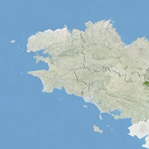
Canvas Print : Departement of Ille-et-Vilaine, France, Relief Map


![]()
Canvas Prints from Universal Images Group (UIG)
Departement of Ille-et-Vilaine, France, Relief Map
Relief map of the departement of Ille-et-Vilaine, France. It is bordered by the English Channel to the north. This image was compiled from data acquired by LANDSAT 5 & 7 satellites combined with elevation data
Universal Images Group (UIG) manages distribution for many leading specialist agencies worldwide
Media ID 9611987
© Planet Observer
Brittany Coastline Geographical Border Relief Map Shore Ille Et Vilaine Satellite View
20"x16" (50x40cm) Canvas Print
Discover the beauty of Ille-et-Vilaine, France, with our stunning Canvas Print from Media Storehouse. This exquisite relief map, sourced from Universal Images Group (UIG), showcases the intricate topography of the department, beautifully rendered in 3D. Compiled from data acquired by LANDSAT 5 & 7 satellites, this unique representation highlights the distinct borders and features of the region, including the English Channel to the north. Elevate your home or office décor with this captivating piece of art that brings the world's geography to life. Order your Media Storehouse Canvas Print of Ille-et-Vilaine, France, today.
Ready to hang Premium Gloss Canvas Print. Our archival quality canvas prints are made from Polyester and Cotton mix and stretched over a 1.25" (32mm) kiln dried knot free wood stretcher bar. Packaged in a plastic bag and secured to a cardboard insert for transit.
Canvas Prints add colour, depth and texture to any space. Professionally Stretched Canvas over a hidden Wooden Box Frame and Ready to Hang
Estimated Product Size is 40.6cm x 50.8cm (16" x 20")
These are individually made so all sizes are approximate
Artwork printed orientated as per the preview above, with portrait (vertical) orientation to match the source image.
FEATURES IN THESE COLLECTIONS
> Europe
> France
> Canton
> Ille
> Maps and Charts
> Related Images
> Universal Images Group (UIG)
> Universal Images Group
> Satellite and Aerial
> Planet Observer 5
EDITORS COMMENTS
This print showcases the stunning relief map of the Departement of Ille-et-Vilaine in France. Located in the beautiful region of Brittany, this departement is bordered by the majestic English Channel to its north. The intricate details and vibrant colors of this image were meticulously compiled from data acquired by LANDSAT 5 & 7 satellites, combined with elevation data. The photograph provides a bird's-eye view of the physical geography and topography of Ille-et-Vilaine. From its picturesque coastline to its undulating landscapes, every contour is clearly visible, making it an invaluable tool for cartographers and geographers alike. The absence of people in this image allows us to fully appreciate nature's artistry at play. As we gaze upon this vertical composition, we are transported into a world where geographical borders dissolve, leaving only awe-inspiring beauty behind. Whether you're an avid photographer or simply fascinated by maps and satellite views, this print offers a unique perspective on one of France's most enchanting regions. Its color palette evokes a sense of tranquility while simultaneously igniting our curiosity about the secrets hidden within Ille-et-Vilaine's diverse terrain
MADE IN THE UK
Safe Shipping with 30 Day Money Back Guarantee
FREE PERSONALISATION*
We are proud to offer a range of customisation features including Personalised Captions, Color Filters and Picture Zoom Tools
SECURE PAYMENTS
We happily accept a wide range of payment options so you can pay for the things you need in the way that is most convenient for you
* Options may vary by product and licensing agreement. Zoomed Pictures can be adjusted in the Basket.