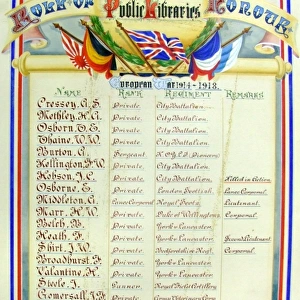
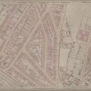
Fine Art Print > Sheffield City Archives > Maps and Plans > Sheffield OS maps
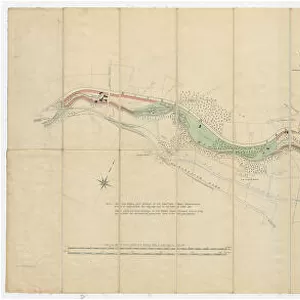
Fine Art Print : Ordnance Survey Map, Somerset Street area, Burngreave, Sheffield, 1889 (Yorkshire sheet no. 294. 4. 22)
")


![]()
Fine Art Prints from Sheffield City Archives
Ordnance Survey Map, Somerset Street area, Burngreave, Sheffield, 1889 (Yorkshire sheet no. 294. 4. 22)
This map features:
Top left: Rock Street, Nottingham Street, Brackley Street, Somerset Road, Catherine Street, Somerset Street, Leicester Villas, Fox Street, Cranworth Road, Brotherton Street, Cliff Rise, Recreation Ground, Farm Bank, Augusta Villas, Cranworth Place, Britannia Villas, Crossby Place, Elgin Place, Oakley House, Marchmount House, Douglas Villas, Princess Villas, Kingston Villas.
Top right: Somerset Road, Catherine Street, Somerset Street, Kilton Hill, Burngreave Road, Richmond Street, Burngreave Road Police Station, Rutland Villas, Somerset View, Catherine Road, Burngreave Bank, Bressingham Road, Burngreave Street, Sandon Villas, Somerset Villas, Arundel Villas, Portland Villas, Storth Villas, Ditchingham Road, Kingston Villas.
Bottom left: Rock Street, Nottingham Street, Brackley Street, Somerset Road, Leicester Villas, Montfort Road, Andover Street, West Andover Street, Lopham Street, Rock Lane, [Andover Street Methodist Church] Methodist New Connexion Chapel (junction of Nottingham Street and Andover Street), Sunday School, Hope Villa, Nottingham Terrace, Post Office, Rock House, Clarendon Place, Beech Villas, Arundel Terrace, Helen Terrace, Fitzalan Street, Verdon Street, Manor View, Rock House, Clifton Villa, Russell Place, Palmerston Place, Blenkarn Place.
Bottom right: Andover Street, Lopham Street, Kilton Hill, Burngreave Road, Richmond Street, Police Station, Rutland Villas, Somerset View, Somerset House, [St, Catherine s] School (Boys & Girls), Andover Street, Playground, St. Catherines R.C. Church Presbytery, Montfort Street, Bramber Street, Stockton Street, Kilton Street, Kilton Lane, Brunswick Road, West Riding Police Station, Andover Street, Leamington Villa, Mona Villas, Hornby Place.
Dimensions of original: 77 x 102 cm.
Scale 10.56 feet : 1 mile [1:500].
From an original at Sheffield Libraries: q00044 (sheet no.
294.4.22)
Sheffield City Archives and Local Studies Library has an unrivalled collection of images of Sheffield, England
Media ID 24220821
© Sheffield City Council - All Rights Reserved
Burngreave Old Map Os Maps Sheffield Yorkshire
A2 (42x59cm) Fine Art Print
Discover the rich history of Sheffield with this stunning Fine Art Print from Media Storehouse. This exquisite reproduction showcases an intricately detailed Ordnance Survey Map of the Burngreave area from 1889. Explore the streets of Somerset, including Rock Street, Nottingham Street, Brackley Street, and more, as they appeared over a century ago. Preserve a piece of Sheffield's past in your home or office with this beautiful and authentic print from Sheffield City Archives.
Our Fine Art Prints are printed on 100% acid free, PH neutral paper with archival properties. This printing method is used by museums and art collections to exhibit photographs and art reproductions. Hahnemühle certified studio for digital fine art printing. Printed on 308gsm Photo Rag Paper.
Our fine art prints are high-quality prints made using a paper called Photo Rag. This 100% cotton rag fibre paper is known for its exceptional image sharpness, rich colors, and high level of detail, making it a popular choice for professional photographers and artists. Photo rag paper is our clear recommendation for a fine art paper print. If you can afford to spend more on a higher quality paper, then Photo Rag is our clear recommendation for a fine art paper print.
Estimated Product Size is 59.4cm x 42cm (23.4" x 16.5")
These are individually made so all sizes are approximate
Artwork printed orientated as per the preview above, with landscape (horizontal) orientation to match the source image.
EDITORS COMMENTS
This print showcases an Ordnance Survey Map of the Somerset Street area in Burngreave, Sheffield from 1889. The map, known as Yorkshire sheet no. 294.4.22, provides a detailed depiction of the neighborhood during that time. The top left section of the map reveals a bustling residential area with streets like Rock Street, Nottingham Street, and Brackley Street lined with charming Leicester Villas and Britannia Villas. Adjacent to these are recreational spots such as Cliff Rise and the Recreation Ground, offering residents ample opportunities for leisurely activities. Moving to the top right corner, we discover more landmarks including Burngreave Road Police Station and Storth Villas along Somerset Road and Catherine Street. This part of town also features notable places like Sandon Villas and Portland Villas. As we shift our attention to the bottom left portion of the map, we encounter Rock Lane leading up to Andover Street Methodist Church (also referred to as Methodist New Connexion Chapel). Other points of interest include Clarendon Place, Beech Villas, Fitzalan Street, Manor View, Russell Place among others. Finally reaching the bottom right quadrant unveils Kilton Hill overlooking Burngreave Road where West Riding Police Station stands tall alongside Leamington Villa and Mona Villas. With dimensions measuring 77 x 102 cm and a scale ratio of 10.56 feet : 1 mile [1:500], this historical artifact offers us a glimpse into Sheffield's past through its intricate details captured on this original document held at Sheffield Libraries under reference q00044 (sheet no. 294.4.22).
MADE IN THE UK
Safe Shipping with 30 Day Money Back Guarantee
FREE PERSONALISATION*
We are proud to offer a range of customisation features including Personalised Captions, Color Filters and Picture Zoom Tools
SECURE PAYMENTS
We happily accept a wide range of payment options so you can pay for the things you need in the way that is most convenient for you
* Options may vary by product and licensing agreement. Zoomed Pictures can be adjusted in the Basket.

![A map of the lands near Attercliffe and Darnall, [?1820s]](/sq/716/map-lands-near-attercliffe-darnall-1820s-18396317.jpg.webp)