Home > Europe > United Kingdom > England > Lincolnshire > Langton
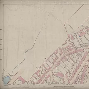
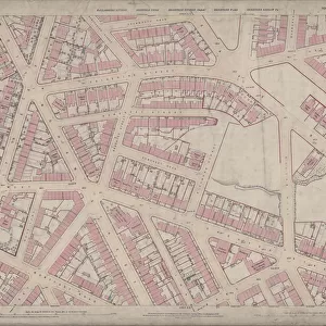
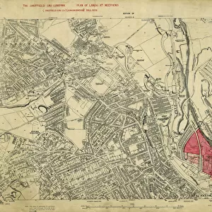
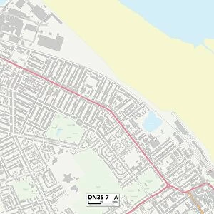
Ordnance Survey Map, Fowler Street, Pitsmoor area of Sheffield, 1889 (Yorkshire sheet no. 294. 4. 21)
")
![]()
Wall Art and Photo Gifts from Sheffield City Archives
Ordnance Survey Map, Fowler Street, Pitsmoor area of Sheffield, 1889 (Yorkshire sheet no. 294. 4. 21)
This map features:
Top left: Rutland Road, [Woodside Board School] School (Girls and Infants), Playground, Botsford Street, Rutland Street, Woodside Lane Birley Street, Fowler Street, Grove Street, Sales Street, Kirkham Place, Fowler Place, Fowler Terrace, Westow Place, Langton Place, Corporation Yard, Stone Yard.
Top right: Grove Street, Sales Street, Fowler Street, United Free Methodist Chapel [Pye Bank Methodist Free Church], Fowler Street Hotel Public House, Haywood Road, Pitsmoor Road, Post Office, Fox and Duck Inn, Bank Top, Victoria Terrace, Chapel Terrace, Victoria Cottage, [Pye Bank Board School] School, Playground, Recreational Ground, Arundel Cottage, Fox Street, Andover Street, West Pye Bank, Gray Street.
Bottom left: Botsford Street, Rutland Street, Woodside Lane, Birley Street, Fowler Street, Macro Street, Wilson Street, Malton Place, Cooper Terrace, Harvest Lane, Platt Street, Bingley Street, Reginald Street, Marshall Street, Wheat Sheaf Inn, Manchester, Sheffield and Lincolnshire Railway.
Bottom right: Grove Street, Marshall Street, Fox Street, Fox Hill, Gray Street, Rock Street, Andover Street West, Victoria Cottage, Chapel Terrace, Bank Rise, Pye Bank, Tower Terrace, Richbell Place, Blenkarn Place, Blenkarn House, Harrington Place, Myrtle Villa, Beech Villa, Arundel Terrace, Tower Hill, Tower House, Grove cottage, Manor View, Hawthorne Cottage, Grove Lodge, Bank House.
Dimensions of original: 77 x 102 cm.
Scale 10.56 feet : 1 mile [1:500].
From an original at Sheffield Libraries: q00043 (sheet no.
294.4.21)
Sheffield City Archives and Local Studies Library has an unrivalled collection of images of Sheffield, England
Media ID 24196955
© Sheffield City Council - All Rights Reserved
Old Map Os Maps Pitsmoor Sheffield Yorkshire
FEATURES IN THESE COLLECTIONS
> Animals
> Insects
> Hemiptera
> Beech Scale
> Architecture
> Towers
> Churches
> Europe
> United Kingdom
> England
> Lincolnshire
> Harrington
> Europe
> United Kingdom
> England
> Lincolnshire
> Langton
> Europe
> United Kingdom
> England
> Manchester
> Manchester
> Europe
> United Kingdom
> England
> Manchester
> Sale
> Europe
> United Kingdom
> England
> Rutland
> Related Images
> Europe
> United Kingdom
> England
> Yorkshire
> Bingley
> Europe
> United Kingdom
> England
> Yorkshire
> Langton
> Europe
> United Kingdom
> England
> Yorkshire
> Malton
> Sheffield City Archives
> Maps and Plans
> Sheffield OS maps
EDITORS COMMENTS
This print showcases an Ordnance Survey Map of the Fowler Street area in Pitsmoor, Sheffield, dating back to 1889. The map, belonging to Yorkshire sheet no. 294.4.21, provides a detailed glimpse into the streets and landmarks that once graced this vibrant neighborhood. In the top left corner of the map, we can spot Rutland Road along with Woodside Board School for Girls and Infants. Adjacent to it lies a bustling playground surrounded by Botsford Street, Rutland Street, Woodside Lane Birley Street, Fowler Street, Grove Street, Sales Street, Kirkham Place, Fowler Place and Fowler Terrace. Moving towards the top right section of the map reveals more intriguing locations such as United Free Methodist Chapel (also known as Pye Bank Methodist Free Church) and Fowler Street Hotel Public House. Other notable spots include Haywood Road, Pitsmoor Road Post Office Fox and Duck Inn on Bank Top. The bottom left portion highlights important areas like Macro Street intersecting with Wilson Street while showcasing Malton Place alongside Cooper Terrace leading up to Harvest Lane. Notably featured is also Platt street merging with Bingley street before reaching Reginald street where Wheat Sheaf Inn stands proudly near Manchester Sheffield and Lincolnshire Railway. Lastly in the bottom right corner unfolds a picturesque view encompassing Tower Hill's grandeur along with Blenkarn House nestled amidst charming residences like Arundel Terrace or Beech Villa. Measuring at an impressive 77 x 102 cm in its original form at Sheffield Libraries: q00043 (sheet no.
294.4.21), this historic artifact offers us a unique perspective on how life unfolded in this part of Sheffield over a century ago.
MADE IN THE UK
Safe Shipping with 30 Day Money Back Guarantee
FREE PERSONALISATION*
We are proud to offer a range of customisation features including Personalised Captions, Color Filters and Picture Zoom Tools
SECURE PAYMENTS
We happily accept a wide range of payment options so you can pay for the things you need in the way that is most convenient for you
* Options may vary by product and licensing agreement. Zoomed Pictures can be adjusted in the Basket.