Fine Art Print > Europe > France > Canton > Landes
Fine Art Print : 17th Century nautical map of the Atlantic


![]()
Fine Art Prints from Science Photo Library
17th Century nautical map of the Atlantic
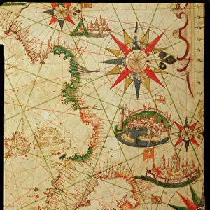
17th Century nautical map of the Atlantic Ocean. Historical portolan chart showing the Atlantic Ocean and adjacent continents. Portolan charts are navigational maps based on realistic descriptions of harbours and coasts. Along with the Atlantic, this chart shows the southeast Pacific Ocean, southwest Indian Ocean and the continents of South America, Africa, Europe, and parts of North America and Asia. Created by Pascal Roiz in 1633
Science Photo Library features Science and Medical images including photos and illustrations
Media ID 6333805
© LIBRARY OF CONGRESS/SCIENCE PHOTO LIBRARY
17th Century Africa African Atlantic Ocean Cartography Chart Diagram Indian Ocean Land Nautical Navigational North American Pacific Ocean South America South American 1633 Portolan
A2 (42x59cm) Fine Art Print
Step back in time with our exquisite selection of Fine Art Prints from the Media Storehouse range. This captivating 17th Century nautical map of the Atlantic Ocean, sourced from the Science Photo Library, transports you to an era of exploration and discovery. With intricate detail and vivid colors, this historical portolan chart showcases the Atlantic Ocean and adjacent continents as they appeared centuries ago. A stunning addition to any home or office, this Fine Art Print is not only a beautiful decorative piece, but also a testament to the rich history of cartography and maritime exploration.
Our Fine Art Prints are printed on 100% acid free, PH neutral paper with archival properties. This printing method is used by museums and art collections to exhibit photographs and art reproductions. Hahnemühle certified studio for digital fine art printing. Printed on 308gsm Photo Rag Paper.
Our fine art prints are high-quality prints made using a paper called Photo Rag. This 100% cotton rag fibre paper is known for its exceptional image sharpness, rich colors, and high level of detail, making it a popular choice for professional photographers and artists. Photo rag paper is our clear recommendation for a fine art paper print. If you can afford to spend more on a higher quality paper, then Photo Rag is our clear recommendation for a fine art paper print.
Estimated Image Size (if not cropped) is 48.8cm x 42cm (19.2" x 16.5")
Estimated Product Size is 59.4cm x 42cm (23.4" x 16.5")
These are individually made so all sizes are approximate
Artwork printed orientated as per the preview above, with landscape (horizontal) orientation to match the source image.
FEATURES IN THESE COLLECTIONS
> Africa
> Related Images
> Africa
> South Africa
> Maps
> Africa
> South Africa
> Related Images
> Animals
> Mammals
> Muridae
> Water Mouse
> Arts
> Artists
> O
> Oceanic Oceanic
> Asia
> Related Images
> Europe
> France
> Canton
> Landes
> Maps and Charts
> Early Maps
EDITORS COMMENTS
This 17th-century nautical map of the Atlantic Ocean takes us back in time to an era of exploration and discovery. Created by Pascal Roiz in 1633, this historical portolan chart offers a detailed depiction of the vast Atlantic and its neighboring continents. Portolan charts were renowned for their navigational accuracy, providing sailors with realistic descriptions of harbors and coastlines. In addition to showcasing the Atlantic Ocean, this remarkable artwork also encompasses parts of the southeast Pacific Ocean, southwest Indian Ocean, South America, Africa, Europe, as well as fragments of North America and Asia. With intricate illustrations and meticulous attention to detail, Roiz's masterpiece transports us into a world where landmasses are beautifully rendered alongside expansive bodies of water. This artful representation serves not only as a testament to cartography but also as a window into our rich maritime history. As we explore this ancient map's contours and study its geographical features—tracing trade routes or imagining daring voyages—we gain insight into the knowledge available during that period. It reminds us how far we have come in understanding our planet while honoring those intrepid explorers who braved uncharted waters centuries ago. Through Science Photo Library's print reproduction of this magnificent piece from their collection—not intended for commercial use—we can appreciate both the artistic beauty and scientific significance encapsulated within this 17th-century treasure.
MADE IN THE UK
Safe Shipping with 30 Day Money Back Guarantee
FREE PERSONALISATION*
We are proud to offer a range of customisation features including Personalised Captions, Color Filters and Picture Zoom Tools
SECURE PAYMENTS
We happily accept a wide range of payment options so you can pay for the things you need in the way that is most convenient for you
* Options may vary by product and licensing agreement. Zoomed Pictures can be adjusted in the Basket.