Fine Art Print > Maps and Charts > World
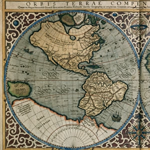
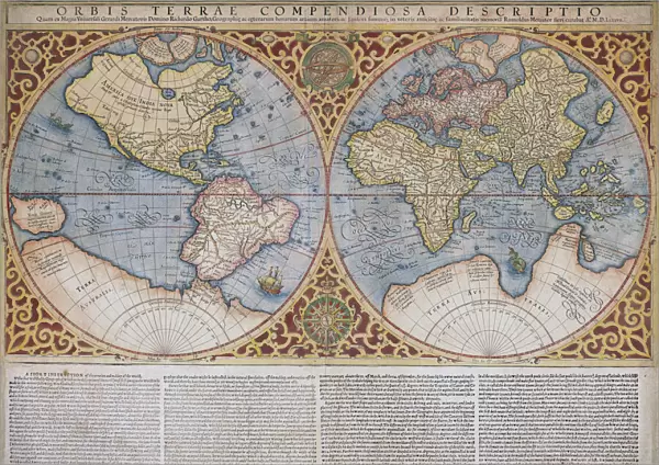
Fine Art Print : Map of the world by Gerard Mercator, first published circa 1595. Orbis terrae compendiosa descriptio


![]()
Fine Art Prints from Design Pics
Map of the world by Gerard Mercator, first published circa 1595. Orbis terrae compendiosa descriptio
Design Pics offers Distinctively Different Imagery representing over 1,500 contributors
Media ID 24904004
© Ken Welsh / Design Pics
16th Century Cartography Countries Décor Decoration Decorative Geographical Geography Wall Art World Double Hemisphere Gerard Mercator Map Making
A2 (42x59cm) Fine Art Print
Discover the captivating beauty of history with our exquisite selection of Fine Art Prints from Media Storehouse. This stunning piece showcases Gerard Mercator's iconic Map of the World, first published in 1595 under the title "Orbis terrae compendiosa descriptio." Mercator's masterpiece is renowned for its intricate detail and accurate representation of the world during the Renaissance era. Bring the rich history of cartography into your home or office with this impressive work of art, perfect for igniting curiosity and inspiring exploration. Order your Fine Art Print today and let the wonders of the world come to you.
Our Fine Art Prints are printed on 100% acid free, PH neutral paper with archival properties. This printing method is used by museums and art collections to exhibit photographs and art reproductions. Hahnemühle certified studio for digital fine art printing. Printed on 308gsm Photo Rag Paper.
Our fine art prints are high-quality prints made using a paper called Photo Rag. This 100% cotton rag fibre paper is known for its exceptional image sharpness, rich colors, and high level of detail, making it a popular choice for professional photographers and artists. Photo rag paper is our clear recommendation for a fine art paper print. If you can afford to spend more on a higher quality paper, then Photo Rag is our clear recommendation for a fine art paper print.
Estimated Product Size is 59.4cm x 42cm (23.4" x 16.5")
These are individually made so all sizes are approximate
Artwork printed orientated as per the preview above, with landscape (horizontal) orientation to match the source image.
FEATURES IN THESE COLLECTIONS
> Maps and Charts
> Early Maps
> Maps and Charts
> Related Images
> Maps and Charts
> World
EDITORS COMMENTS
This stunning print showcases the remarkable "Map of the world by Gerard Mercator" a masterpiece first published circa 1595. Known as Orbis terrae compendiosa descriptio, this map is a true testament to Mercator's skill and artistry in cartography. With its vibrant colors and intricate details, this illustration transports us back to the 16th century, offering a glimpse into the geographical and historical knowledge of that era. The double hemisphere design allows us to explore different continents and countries, providing an invaluable snapshot of how our world was perceived at that time. The Welsh artist Ken has beautifully captured every aspect of this old-world map, making it an ideal choice for wall art or decorative purposes. Its rich hues and fine craftsmanship add elegance and sophistication to any space. Whether you're a history enthusiast or simply appreciate the beauty of vintage maps, this print is sure to captivate your imagination. It serves as a reminder of how far we've come in terms of geography while honoring the legacy left behind by Gerard Mercator – one of history's most influential figures in map-making
MADE IN THE UK
Safe Shipping with 30 Day Money Back Guarantee
FREE PERSONALISATION*
We are proud to offer a range of customisation features including Personalised Captions, Color Filters and Picture Zoom Tools
SECURE PAYMENTS
We happily accept a wide range of payment options so you can pay for the things you need in the way that is most convenient for you
* Options may vary by product and licensing agreement. Zoomed Pictures can be adjusted in the Basket.