Home > Africa > South Africa > Maps
A Plan of the Dutch Fort at the Cape of Good Hope and A Draught of Table Bay (engraving)
")
![]()
Wall Art and Photo Gifts from Fine Art Finder
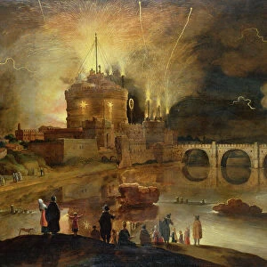
A Plan of the Dutch Fort at the Cape of Good Hope and A Draught of Table Bay (engraving)
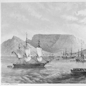
XJF437999 A Plan of the Dutch Fort at the Cape of Good Hope and A Draught of Table Bay (engraving) by English School, (18th century); Private Collection; (add.info.: A Plan of the star fort, also known as the Castle of Good Hope, that the Dutch East India Company built between 1666 and 1679; This fortified stone structure was built as a result of the agitations with the British, replacing an earlier wooden stucture that had been built to serve as a as a replenishment station for ships passing the treacherous Cape on the long voyage between the Netherlands and the Dutch East Indies; The draught of Table Bay shows Robben Island, that was used to isolate political prisoners and notes the location of Good Hope Castle as well as Table Mountain; The accompanying inscription tells of a plan to build a protective pier between the main land and Penguin Island in order to provide more shelter for ships anchored in the bay, as well as plans for further fortifications; ); English, out of copyright
Media ID 12880997
© www.bridgemanart.com
Birds Eye View Cartographic Cartography Colony Defenses Defensive Fortifications Geographical Settlement Spice Trade
FEATURES IN THESE COLLECTIONS
> Africa
> South Africa
> Maps
> Africa
> South Africa
> South Africa Heritage Sites
> Robben Island
> Animals
> Birds
> Penguins
> Related Images
> Europe
> Netherlands
> Castles
> Europe
> Netherlands
> Maps
> Fine Art Finder
> Maps (celestial & Terrestrial)
> Fine Art Finder
> Schools
> English School
> Maps and Charts
> India
> Maps and Charts
> Netherlands
EDITORS COMMENTS
This print showcases "A Plan of the Dutch Fort at the Cape of Good Hope and A Draught of Table Bay" an engraving created by an English School in the 18th century. The artwork, part of a private collection, offers a glimpse into the historical significance and strategic importance of this fortified stone structure known as the Castle of Good Hope. Constructed between 1666 and 1679 by the Dutch East India Company, this star fort replaced an earlier wooden structure that served as a replenishment station for ships traveling between the Netherlands and the Dutch East Indies. The plan reveals intricate details about its design, highlighting its defensive features against potential British agitations during that time. The accompanying draught depicts Table Bay with notable landmarks such as Robben Island, which was famously used to isolate political prisoners. It also pinpoints both Good Hope Castle and Table Mountain within its frame. Furthermore, an inscription on this engraving discloses plans to build a protective pier connecting Penguin Island to mainland in order to provide additional shelter for ships anchored in the bay. Additionally, it references future fortification projects. This print not only captures a significant piece of history but also invites viewers to explore colonial tensions and maritime advancements during this era. Its preservation through time allows us to appreciate both its artistic merit and valuable insights into past events at one of South Africa's most iconic locations.
MADE IN THE UK
Safe Shipping with 30 Day Money Back Guarantee
FREE PERSONALISATION*
We are proud to offer a range of customisation features including Personalised Captions, Color Filters and Picture Zoom Tools
FREE COLORIZATION SERVICE
You can choose advanced AI Colorization for this picture at no extra charge!
SECURE PAYMENTS
We happily accept a wide range of payment options so you can pay for the things you need in the way that is most convenient for you
* Options may vary by product and licensing agreement. Zoomed Pictures can be adjusted in the Basket.