Home > Arts > Artists > B > Grazioso Benincasa
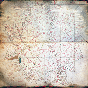
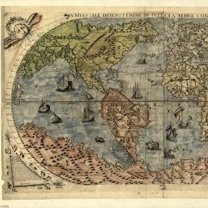
Map of the Central Mediterranean (ink on parchment)
")
![]()
Wall Art and Photo Gifts from Fine Art Finder
Map of the Central Mediterranean (ink on parchment)
XCF307338 Map of the Central Mediterranean (ink on parchment) by Benincasa, Grazioso (fl.1468); Private Collection; Italian, out of copyright
Media ID 12841959
© www.bridgemanart.com
Atlas Chart Corsica Geographical Islands Mapping Northafrica Sardinia Sicily
FEATURES IN THESE COLLECTIONS
> Arts
> Art Movements
> Renaissance Art
> Arts
> Artists
> B
> Grazioso Benincasa
> Arts
> Artists
> O
> Oceanic Oceanic
> Europe
> Italy
> Lazio
> Rome
> Europe
> Italy
> Sardinia
> Related Images
> Europe
> Italy
> Sicily
> Related Images
> Fine Art Finder
> Artists
> Grazioso Benincasa
> Historic
> Renaissance art
> Italian Renaissance art
EDITORS COMMENTS
This print showcases a remarkable piece of cartographic history - the "Map of the Central Mediterranean". Created by the talented Italian cartographer Grazioso Benincasa in 1468, this ink on parchment masterpiece is a true testament to his skill and dedication. The map takes us back in time to an era of great exploration and discovery, when sailors braved treacherous waters to chart unknown territories. It offers a detailed depiction of the central Mediterranean region, encompassing Rome, Italy, North Africa, and various islands such as Sicily, Sardinia, and Corsica. Every stroke of ink on this ancient parchment tells a story of geographical knowledge passed down through generations. The intricate details highlight coastlines and ocean currents with precision that was groundbreaking for its time. As we gaze upon this Renaissance-era treasure, we are transported to an age where maps were not just navigational tools but works of art. Its historical significance cannot be overstated; it serves as a window into how our ancestors perceived their world. Now preserved within a private collection but made accessible through this stunning print from Fine Art Finder's extensive catalogue at www. bridgemanart. com , we can appreciate both the beauty and educational value that lies within this extraordinary piece. Let it inspire us to explore new horizons while cherishing the rich heritage left behind by those who came before us.
MADE IN THE UK
Safe Shipping with 30 Day Money Back Guarantee
FREE PERSONALISATION*
We are proud to offer a range of customisation features including Personalised Captions, Color Filters and Picture Zoom Tools
SECURE PAYMENTS
We happily accept a wide range of payment options so you can pay for the things you need in the way that is most convenient for you
* Options may vary by product and licensing agreement. Zoomed Pictures can be adjusted in the Basket.