Home > Animals > Mammals > Black Bear
Map to Illustrate the Route of Prince Maximilian of Wied in the Interior of North America from Boston to the Upper Missouri, 1839 (engraving)
")
![]()
Wall Art and Photo Gifts from Fine Art Finder
Map to Illustrate the Route of Prince Maximilian of Wied in the Interior of North America from Boston to the Upper Missouri, 1839 (engraving)
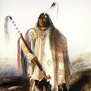
5054760 Map to Illustrate the Route of Prince Maximilian of Wied in the Interior of North America from Boston to the Upper Missouri, 1839 (engraving) by Bodmer, Karl (1809-93); Joslyn Museum, Omaha, Nebraska, USA; (add.info.: Travels of Prince Alexander Phillip Maximilian of Wied and the young Swiss artist Karl Bodmer in the Plains and Rocky Mountain regions, 1832-34
Extends west to the Rockies, with Missouri and Upper Mississippi Rivers inset, and a striking cartouche of Native Americans hunting buffalo on horseback.)
Media ID 24711966
© Bridgeman Images
American Native Indians American West Atlantic Atlantic Ocean Bear Bears Black Bears Boston British Colony Buffalo Cartography Cartouche City Map City Plan Civilisation Colonial America Cultural Deer Excursion Expedition Explore Fallow Deer Fawn Fresh Air General Map Geographical Geographical Map Great Lakes Indigenous Peoples Of The Americas Indigineous Louisiana Purchase Mapping Massachussets Mauri Mississippi Missouri Mountain Lake Natures Pond Stag State Hunting Street Plan Topographical America Continent Canadians
FEATURES IN THESE COLLECTIONS
> Animals
> Mammals
> Black Bear
> Animals
> Mammals
> Muridae
> Plains Mouse
> Animals
> Mammals
> Ursidae
> American Black Bear
> Animals
> Wild
> Bears
> American Black Bear
> Animals
> Wild
> Related Images
> Arts
> Artists
> B
> Karl Bodmer
> Arts
> Landscape paintings
> Coastal landscapes
> Nature-inspired artwork
> Arts
> Landscape paintings
> Waterfall and river artworks
> Nature-inspired paintings
> Europe
> Switzerland
> Lakes
> Related Images
> Europe
> Switzerland
> Maps
> Fine Art Finder
> Artists
> Karl Bodmer
EDITORS COMMENTS
This engraving, titled "Map to Illustrate the Route of Prince Maximilian of Wied in the Interior of North America from Boston to the Upper Missouri, 1839" takes us on a visual journey through the vast and untamed landscapes of 19th century North America. Created by Karl Bodmer, a talented Swiss artist, this map showcases the travels of Prince Alexander Phillip Maximilian of Wied as they ventured into the Plains and Rocky Mountain regions between 1832-34. The map extends westward towards the majestic Rockies, with detailed insets depicting both Missouri and Upper Mississippi Rivers. However, it is not just a mere geographical representation; it also offers a glimpse into Native American culture during that time period. A striking cartouche captures Native Americans skillfully hunting buffalo on horseback – an awe-inspiring testament to their deep connection with nature. As we explore this intricate engraving further, we are reminded of the spirit of discovery that characterized early expeditions in colonial America. From Boston to Massachussets and beyond, this map serves as a historical artifact documenting exploration and mapping efforts during this era. With its vibrant colors and attention to detail, Bodmer's masterpiece transports us back in time – allowing us to immerse ourselves in an age when wildlife roamed freely across uncharted territories. It reminds us that even amidst great change and expansion across North America, there was still beauty to be found in its untouched wilderness.
MADE IN THE UK
Safe Shipping with 30 Day Money Back Guarantee
FREE PERSONALISATION*
We are proud to offer a range of customisation features including Personalised Captions, Color Filters and Picture Zoom Tools
SECURE PAYMENTS
We happily accept a wide range of payment options so you can pay for the things you need in the way that is most convenient for you
* Options may vary by product and licensing agreement. Zoomed Pictures can be adjusted in the Basket.