Home > Arts > Artists > G > Giovanni di Paolo di Grazia
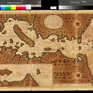
Map of the Bay of Darien, 1709-13 (colour litho)
")
![]()
Wall Art and Photo Gifts from Fine Art Finder
Map of the Bay of Darien, 1709-13 (colour litho)
VEN1126513 Map of the Bay of Darien, 1709-13 (colour litho) by Keulen, Gerard van (1678-1726); Biblioteca Angelica, Rome, Italy; (add.info.: Darien is a province in Panama whose capital city is La Palma. With an area of 11, 896.5 km2 (4, 593.3 sq mi), it is located at the eastern end of the country and bordered to the north by the province of Panama and the region of Kuna Yala. To the south, it is bordered by the Pacific Ocean and Colombia. To the east, it borders Colombia; to the west, it borders the Pacific Ocean and the province of Panama.); © Marage Photos
Media ID 23314922
© Marage Photos / Bridgeman Images
British Explorer Cartographer Cartography Central Colombia Pacific Panama Province William Dampier Darien
FEATURES IN THESE COLLECTIONS
> Arts
> Artists
> G
> Giovanni di Paolo di Grazia
> Arts
> Artists
> P
> Giovanni Di Paolo
> Europe
> Italy
> Lazio
> Rome
> Fine Art Finder
> Artists
> Gerard van Keulen
> Fine Art Finder
> Artists
> Giovanni di Paolo di Grazia
> Fine Art Finder
> Maps (celestial & Terrestrial)
> Maps and Charts
> Italy
> North America
> Panama
> Maps
EDITORS COMMENTS
This vibrant and detailed lithograph, titled "Map of the Bay of Darien, 1709-13" takes us back in time to explore the geography and history of this fascinating region. Created by Dutch cartographer Gerard van Keulen, this print showcases his meticulous attention to detail and skillful craftsmanship. The map depicts the Bay of Darien, a province located at the eastern end of Panama. Stretching across an area of over 11,000 square kilometers, it is bordered by both Colombia and the Pacific Ocean. The capital city, La Palma, serves as its cultural hub. As we delve into this historical piece, we discover that it holds significance for British exploration as well. Notably featured on the map is William Dampier, a renowned English explorer who ventured through these lands during his travels. With its rich colors and intricate illustrations, this lithograph offers a glimpse into not only the geographical features but also the cultural heritage of this region. It serves as a testament to Van Keulen's expertise in capturing both accuracy and beauty in his cartographic works. Whether you are an avid historian or simply intrigued by maps and their stories, "Map of the Bay of Darien" transports you to a time when explorers roamed these lands in search of new adventures and discoveries.
MADE IN THE UK
Safe Shipping with 30 Day Money Back Guarantee
FREE PERSONALISATION*
We are proud to offer a range of customisation features including Personalised Captions, Color Filters and Picture Zoom Tools
SECURE PAYMENTS
We happily accept a wide range of payment options so you can pay for the things you need in the way that is most convenient for you
* Options may vary by product and licensing agreement. Zoomed Pictures can be adjusted in the Basket.