
Maps Collection
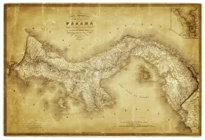
The Republic of Panama is located in Central America, bordered by Costa Rica to the west
Choose a picture from our Maps Collection for your Wall Art and Photo Gifts
165 items


All Professionally Made to Order for Quick Shipping
-
Maps Collection
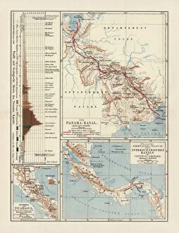
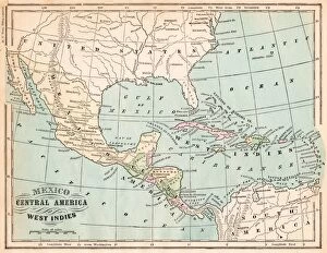
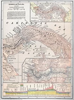
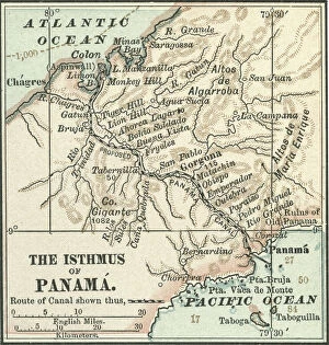
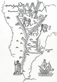
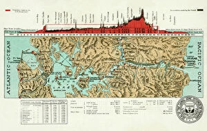
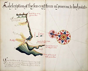
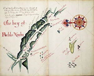
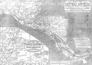
The Republic of Panama is located in Central America, bordered by Costa Rica to the west, Colombia to the southeast and the Caribbean Sea to the north and has a population of approximately 4 million people and its capital is Panama City. Maps of Panama North America show that it has a total area of 75,517 square kilometers (29,157 square miles). The country is divided into nine provinces and five indigenous territories. It also has two major mountain ranges: the Cordillera de Talamanca in the east and the Serrania de Tabasará in the west. The main rivers are Chagres River, which flows through Panama City; Rio Grande de Chiriqui; Rio San Juan; and Rio Chepo. Other features include numerous islands along both coasts as well as several lakes such as Gatun Lake on its Atlantic side. Its climate is tropical with hot wet summers and mild dry winters making it an ideal destination for tourists looking for a warm getaway year-round.
+
Our beautiful pictures are available as Framed Prints, Photos, Wall Art and Photo Gifts
The Maps of Panama North America collection is a series of wall art and framed prints available from Media Storehouse. Our collection features a variety of maps depicting the country of Panama, including antique maps dating back to the 16th century as well as more modern representations. These maps showcase the geographical features, landmarks, and cities within Panama, providing an interesting historical perspective on this Central American nation. Each print in the Maps of Panama North America collection is carefully crafted using high-quality materials to ensure longevity and durability. Customers can choose from a range of sizes and framing options to suit their individual preferences and decor styles. Whether you're looking for a unique piece of artwork for your home or simply want to explore the history and geography of Panama through stunning visual representations, the Maps of Panama North America collection has something for everyone.
+
What are Maps of Panama North America art prints?
Maps of Panama North America art prints are high-quality reproductions of vintage and contemporary maps depicting the region. These prints showcase the intricate details, topography, and geographical features of Panama and its surrounding areas in North America. They are perfect for those who appreciate history, geography or simply want to add a touch of sophistication to their home or office decor. These art prints come in various sizes and formats such as canvas, framed paper or unframed paper. The canvas option provides a modern look while the framed paper option adds elegance to any room. Unframed paper is ideal for those who prefer custom framing options. Whether you're looking for a unique gift idea or something special for yourself, Maps of Panama North America art prints offer an excellent choice that will surely impress anyone with an interest in cartography or travel. With their exceptional quality and attention to detail, these art prints are sure to become cherished possessions that can be enjoyed for years to come.
+
What Maps of Panama North America art prints can I buy from Media Storehouse?
We offer a wide range of Maps of Panama North America art prints that you can buy. These maps are available in various sizes and styles, including vintage, antique, and modern designs. You can choose from different types of maps such as political, physical, topographical or satellite imagery to suit your preferences. The collection includes detailed maps that showcase the geography and landmarks of Panama and North America. Some popular options include the map of Panama Canal Zone showing its intricate network of locks and waterways; the map depicting the United States' westward expansion during 19th century; or a colorful illustrated map highlighting major cities in North America. These high-quality art prints are perfect for home decor or office spaces. They make great gifts for history buffs, travelers or anyone who appreciates cartography. With our vast selection of Maps of Panama North America art prints to choose from, you're sure to find one that fits your style.
+
How do I buy Maps of Panama North America art prints?
To buy Maps of Panama North America art prints from Media Storehouse, you can start by browsing our extensive collection of high-quality maps. Once you have found the map that you like, simply select the size and format that suits your needs. You can choose from a range of options such as canvas prints, framed prints, or poster prints. After selecting your preferred format and size, add the item to your cart and proceed to checkout. At this stage, you will be prompted to provide your shipping details and payment information. We offer secure payment options such as credit card or PayPal for hassle-free transactions. Once your order is confirmed, it will be processed promptly and shipped directly to your doorstep. Whether you are looking for a vintage map of Panama or a modern rendition of North America's topography, we have got you covered with their vast selection of maps in various styles and formats.
+
How much do Maps of Panama North America art prints cost?
Maps of Panama North America art prints are available at Media Storehouse. The cost of these prints may vary depending on the size, quality, and type of paper used for printing. However, we offer a wide range of options to choose from that will suit your budget and preferences. The prices for Maps of Panama North America art prints are reasonable and affordable. You can find high-quality prints that fit within your budget without compromising on the quality or clarity of the image. Media Storehouse is known for offering excellent customer service and providing customers with a hassle-free shopping experience. They have a vast collection of maps, including vintage maps, antique maps, topographic maps, political maps, and more. If you're looking to purchase Maps of Panama North America art prints at an affordable price without sacrificing quality or clarity in the image - then Media Storehouse is an excellent choice.
+
How will my Maps of Panama North America art prints be delivered to me?
Your Maps of Panama North America art prints will be delivered to you in a safe and secure manner by Media Storehouse. The company takes great care in packaging your artwork to ensure that it arrives at your doorstep undamaged. Your prints will be carefully rolled up and placed inside a sturdy tube for protection during shipping. Media Storehouse uses reliable courier services to deliver your order, ensuring that it reaches you within the estimated delivery time frame. You can track the progress of your shipment online using the tracking number provided by the company. Upon receiving your package, make sure to handle it with care while unrolling the prints from their protective tube. Once unrolled, you can choose to display them as they are or have them framed according to your preference. Media Storehouse strives to provide its customers with a hassle-free experience when it comes to delivering high-quality art prints straight into their homes.