Home > Arts > Artists > A > Aaron Arrowsmith
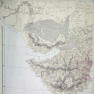
Map of India, 1822 (colour litho)
")
![]()
Wall Art and Photo Gifts from Fine Art Finder
Map of India, 1822 (colour litho)
XCF275017 Map of India, 1822 (colour litho) by Arrowsmith, Aaron (fl.1810); Private Collection; British, out of copyright
Media ID 12790595
© www.bridgemanimages.com
Bhutan British Empire British India Cartography East India Company Frontier Geographical Mapping Nepal
FEATURES IN THESE COLLECTIONS
> Arts
> Artists
> A
> Aaron Arrowsmith
> Fine Art Finder
> Artists
> Aaron Arrowsmith
> Maps and Charts
> British Empire Maps
> Maps and Charts
> India
EDITORS COMMENTS
This print showcases a beautifully detailed "Map of India, 1822" created by the talented cartographer Aaron Arrowsmith. With its vibrant colors and intricate design, this lithograph offers a glimpse into the historical geography of British India during the colonial era. The map highlights not only the vast expanse of British-controlled territories but also includes neighboring regions such as Nepal and Bhutan. It serves as a testament to the East India Company's influence in shaping borders and frontiers within the Indian subcontinent. As we delve into this piece, we are transported back in time to an era when cartography played a crucial role in expanding empires and establishing dominance over new lands. The attention to detail is remarkable, allowing us to explore various geographical features like rivers, mountains, cities, and coastlines that were essential for trade routes and strategic military planning. Beyond its aesthetic appeal, this map holds immense historical significance. It represents an era marked by British imperialism and colonization—a period that shaped modern-day India's political landscape. This visual representation provides valuable insights into how boundaries were drawn during this pivotal time in history. With its rich colors and meticulous craftsmanship, this print invites us on a journey through time—an exploration of both artistry and historical context. Whether you're fascinated by maps or interested in understanding colonial legacies better, this exquisite lithograph is sure to captivate your imagination.
MADE IN THE UK
Safe Shipping with 30 Day Money Back Guarantee
FREE PERSONALISATION*
We are proud to offer a range of customisation features including Personalised Captions, Color Filters and Picture Zoom Tools
SECURE PAYMENTS
We happily accept a wide range of payment options so you can pay for the things you need in the way that is most convenient for you
* Options may vary by product and licensing agreement. Zoomed Pictures can be adjusted in the Basket.