Home > Asia > Bangladesh > Maps
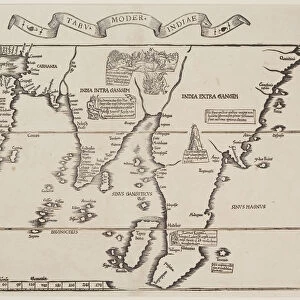
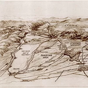
India Circa 1930. Before Partition. From Bacons Excelsior Atlas Of The World, Published Circa 1930

![]()
Wall Art and Photo Gifts from Design Pics
India Circa 1930. Before Partition. From Bacons Excelsior Atlas Of The World, Published Circa 1930
Design Pics offers Distinctively Different Imagery representing over 1,500 contributors
Media ID 18191536
© Ken Welsh / Design Pics
Atlas Before Bengal Between Cartography East First India Pakistan Prior Second Wars World Bangladesh Partition
FEATURES IN THESE COLLECTIONS
> Asia
> Bangladesh
> Maps
> Asia
> Bangladesh
> Related Images
> Asia
> India
> Related Images
> Asia
> Pakistan
> Related Images
> Historic
> World War I and II
> World War I
> Historic
> World War I and II
> World War II
> Maps and Charts
> India
> Maps and Charts
> Related Images
EDITORS COMMENTS
This print titled "India Circa 1930. Before Partition" takes us back in time to a significant era in Indian history. Published around the same period, this image is extracted from Bacons Excelsior Atlas Of The World, offering a glimpse into the geopolitical landscape of pre-partition India. The photograph showcases an intricately detailed map that delineates the region's boundaries before the division between India and Pakistan took place. It serves as a poignant reminder of how political decisions can reshape nations and alter their destinies forever. With its rich cartography, this print allows us to explore the vast expanse of undivided Bengal, which encompassed present-day Bangladesh and West Bengal in India. It evokes nostalgia for a time when these regions were united under one administrative unit. As we delve deeper into this visual representation, it becomes apparent that this snapshot was captured during a tumultuous period marked by two devastating world wars. The first and second world wars had profound implications on global politics and played an influential role in shaping the future of many countries worldwide. Ken Welsh's expertise shines through his careful selection of historical imagery, enabling viewers to immerse themselves in moments frozen in time. This particular print stands as an invaluable testament to our shared past and invites contemplation on how historical events continue to shape our present reality.
MADE IN THE UK
Safe Shipping with 30 Day Money Back Guarantee
FREE PERSONALISATION*
We are proud to offer a range of customisation features including Personalised Captions, Color Filters and Picture Zoom Tools
SECURE PAYMENTS
We happily accept a wide range of payment options so you can pay for the things you need in the way that is most convenient for you
* Options may vary by product and licensing agreement. Zoomed Pictures can be adjusted in the Basket.