Home > Asia > Bangladesh > Maps
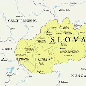
Map of Bangladesh

![]()
Wall Art and Photo Gifts from Universal Images Group (UIG)
Map of Bangladesh
Universal Images Group (UIG) manages distribution for many leading specialist agencies worldwide
Media ID 9539777
© Dorling Kindersley/UIG
Atlas Bangladesh Country Geography South Asia
FEATURES IN THESE COLLECTIONS
> Asia
> Bangladesh
> Maps
> Universal Images Group (UIG)
> Illustrations
> Illustrations 1
EDITORS COMMENTS
This print showcases the intricate and vibrant "Map of Bangladesh" created by Dorling Kindersley. With its meticulous attention to detail, this illustration beautifully captures the essence of this South Asian country's geography. The map is a testament to the artistry and skill of cartography, presenting an accurate representation of Bangladesh's diverse landscapes. From the lush greenery that blankets its fertile plains to the meandering rivers that crisscross its territory, every feature on this map comes alive in vivid color. It offers a visual journey through bustling cities like Dhaka, Chittagong, and Khulna while also highlighting natural wonders such as Cox's Bazar Beach and Sundarbans National Park. As one gazes upon this stunning piece of artwork, it becomes apparent that it holds more than just geographical information; it tells a story about Bangladesh's rich history and cultural heritage. Each region is marked with symbols representing local traditions, landmarks, or historical events - providing viewers with glimpses into the tapestry of Bangladeshi life. Whether you are an avid traveler planning your next adventure or simply fascinated by maps' beauty and significance, this print will undoubtedly captivate your imagination. It serves as both an educational tool for students studying geography or history and a decorative piece for those seeking to adorn their walls with something truly unique. Dorling Kindersley has once again proven their mastery in creating visually stunning atlases that inspire exploration and curiosity about our world. This print from Universal Images
MADE IN THE UK
Safe Shipping with 30 Day Money Back Guarantee
FREE PERSONALISATION*
We are proud to offer a range of customisation features including Personalised Captions, Color Filters and Picture Zoom Tools
SECURE PAYMENTS
We happily accept a wide range of payment options so you can pay for the things you need in the way that is most convenient for you
* Options may vary by product and licensing agreement. Zoomed Pictures can be adjusted in the Basket.