Fraud Blocker Skip to main content

Home > Maps and Charts > British Empire Maps

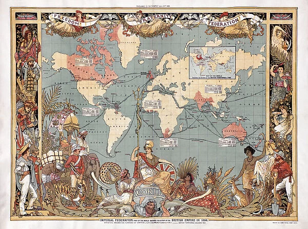
Map of the world showing the extent of the British Empire in 1886. The Empires territories are marked in red. The map was included as a supplement in the July 24, 1886 edition of the British weekly illustrated newspaper The Graphic

Map of the world showing the extent of the British Empire in 1886. The Empires territories are marked in red. The map was included as a supplement in the July 24, 1886 edition of the British weekly illustrated newspaper The Graphic


Photo Prints
Jigsaw Puzzles
Poster Prints
Canvas Prints
Fine Art Prints
Mounted Prints
Metal Prints
Cards
Home Decor


We accept all major credit cards

Design Pics

Wall Art and Photo Gifts from Design Pics

Map of the world showing the extent of the British Empire in 1886. The Empires territories are marked in red. The map was included as a supplement in the July 24, 1886 edition of the British weekly illustrated newspaper The Graphic

Design Pics offers Distinctively Different Imagery representing over 1,500 contributors

Media ID 24905851

© Ken Welsh

British Empire Cartography Colonies Countries Geographical Geography Territories The Graphic World 1886 Empires


FEATURES IN THESE COLLECTIONS

> Design Pics > Historical

> Design Pics > Vintage Maps

> Maps and Charts > British Empire Maps

> Maps and Charts > Early Maps

> Maps and Charts > Related Images

> Maps and Charts > World


EDITORS COMMENTS
This print showcases a historical artifact that takes us back to the late 19th century, specifically to the year 1886. The image depicts a detailed map of the world, highlighting the vast extent of the British Empire during that time. The territories under British rule are boldly marked in red, vividly illustrating their dominance across various continents. Originally published as a supplement in the July 24, 1886 edition of The Graphic, a renowned British weekly illustrated newspaper, this map provides invaluable insights into an era when empires were at their peak. It serves as both a testament to Britain's global influence and an important historical document. The intricate illustration offers viewers a glimpse into how countries and colonies were distributed throughout this expansive empire. It invites us to explore not only geographical aspects but also delve into questions surrounding imperialism and colonialism prevalent during that period. Preserved within archives for over a century, this old cartographic gem allows us to reflect on our shared history and appreciate how far we have come since then. Its significance lies not only in its visual appeal but also in its ability to spark curiosity about past events and encourage discussions about power dynamics between nations. Ken Welsh's expert capture ensures that this remarkable piece remains accessible for generations to come – an enduring reminder of an empire's reach etched onto paper.

MADE IN THE UK
Safe Shipping with 30 Day Money Back Guarantee

FREE PERSONALISATION*
We are proud to offer a range of customisation features including Personalised Captions, Color Filters and Picture Zoom Tools

SECURE PAYMENTS
We happily accept a wide range of payment options so you can pay for the things you need in the way that is most convenient for you

* Options may vary by product and licensing agreement. Zoomed Pictures can be adjusted in the Basket.


redeem
Beautiful Photo Prints and Gifts
image
Professionally Printed
inventory
Photo Prints are in stock
thumb_up
Professional quality finish
diamond
Made with high-grade materials
inventory_2
Carefully packed to aid safe arrival


Related Images


Statue and Kala Bhairab, Durbar Square (UNESCO World Heritage Site), Kathmandu, Nepal
Propaganda poster issued by the British Empire Union, pub. London, c. 1918 (colour litho)
Certificate issued to schoolchildren of the British Empire for sending Christmas gifts to members of the armed forces during World War I, 1916 (chromolitho)
f1, formula 1, formula one, testing, test, xxx
Orders of Knighthood of the British Empire and the Victoria Cross (chromolitho)
Regency man with a cudgel riding a horse prone to tumbling
The Assembly Rooms on the Race Ground near Madras, plate 37 from Oriental Scenery
Defenders of the Empire, dedicated to the Army and Navy (colour litho)
The British Empire (colour litho)
The Spirit of Empire, drawing for an advertisement for Dewars Scotch whisky (litho)
Imperial Federation (colour litho)
J Speed, The Theatre of the Empire of Great Britaine, J Sudbury and G Humble 1611 (b / w photo)

+

Shipping

+

Choices

+

Reviews

+

Guaranteed


Related Collections


British Empire Maps
British Empire Maps
Browse 542 Prints
Early Maps
Early Maps
Browse 24,655 Prints
Vintage Maps
Vintage Maps
Browse 452 Prints
Maps and Charts Related Images
Browse 46,910 Prints
World
World
Browse 6,673 Prints
Historical
Historical
Browse 14,199 Prints