Canvas Print > Animals > Mammals > Didelphidae > Formosa
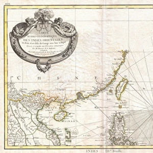
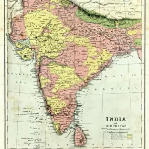
Canvas Print : 1770, Bonne Map of China, Korea, Japan and Formosa, Rigobert Bonne 1727 - 1794, one


![]()
Canvas Prints from Liszt Collection
1770, Bonne Map of China, Korea, Japan and Formosa, Rigobert Bonne 1727 - 1794, one
1770, Bonne Map of China, Korea, Japan and Formosa, Rigobert Bonne 1727 - 1794, one of the most important cartographers of the late 18th century
Liszt Collection of nineteenth-century engravings and images to browse and enjoy
Media ID 14004660
© Artokoloro Quint Lox Limited
1770 Korea Rigobert Bonne 1727 1794 Rigobert Bonne 1727 – 1794 Rigobert Bonne 17271794 Antique Map Latitude Longitude Mappa Mundi Old Antique Plan Old Antique View Ols Antique Map Rare Old Maps Topo
20"x16" (50x40cm) Canvas Print
Discover the captivating allure of the past with our exquisite Canvas Print of the 1770 Rigobert Bonne Map of China, Korea, Japan, and Formosa. Hailing from the prestigious Liszt Collection, this map, created by the renowned cartographer Rigobert Bonne in 1770, offers a fascinating glimpse into the geographical knowledge of the late 18th century. Each detail is meticulously rendered, from the intricate coastlines to the vivid depictions of cities and landmarks. Elevate your home or office décor with this stunning and historically significant piece, sure to spark intrigue and conversation among visitors.
Ready to hang Premium Gloss Canvas Print. Our archival quality canvas prints are made from Polyester and Cotton mix and stretched over a 1.25" (32mm) kiln dried knot free wood stretcher bar. Packaged in a plastic bag and secured to a cardboard insert for transit.
Canvas Prints add colour, depth and texture to any space. Professionally Stretched Canvas over a hidden Wooden Box Frame and Ready to Hang
Estimated Product Size is 50.8cm x 40.6cm (20" x 16")
These are individually made so all sizes are approximate
Artwork printed orientated as per the preview above, with landscape (horizontal) orientation to match the source image.
FEATURES IN THESE COLLECTIONS
> Animals
> Mammals
> Didelphidae
> Formosa
> Asia
> Japan
> Related Images
> Europe
> France
> Canton
> Landes
> Historic
> Space exploration
> Maps and Charts
> Early Maps
> Maps and Charts
> Related Images
> Maps and Charts
> World
EDITORS COMMENTS
This vintage print showcases the remarkable 1770 Bonne Map of China, Korea, Japan, and Formosa by Rigobert Bonne. As one of the most influential cartographers of the late 18th century, Bonne's expertise in topography and geography is evident in this intricate illustration. The map provides a fascinating glimpse into the world as it was known during that time period. With its detailed depiction of landforms and geographical features, this historic piece offers a valuable resource for exploration and navigation. The carefully marked grid lines indicate latitude and longitude coordinates, allowing travelers to accurately navigate through these regions centuries ago. The aged appearance adds to its charm, making it an artful decorative item that transports us back to a bygone era. This rare antique map not only serves as a testament to Bonne's skill but also represents an important chapter in our understanding of historical geography. Whether you are a history enthusiast or simply appreciate fine craftsmanship, this print from the Liszt Collection will surely ignite your curiosity about ancient civilizations and their connections across vast spaces. It serves as both an educational tool and a beautiful piece of artwork that captures the spirit of discovery prevalent during Rigobert Bonne's time.
MADE IN THE UK
Safe Shipping with 30 Day Money Back Guarantee
FREE PERSONALISATION*
We are proud to offer a range of customisation features including Personalised Captions, Color Filters and Picture Zoom Tools
SECURE PAYMENTS
We happily accept a wide range of payment options so you can pay for the things you need in the way that is most convenient for you
* Options may vary by product and licensing agreement. Zoomed Pictures can be adjusted in the Basket.