
Canvas Print > Fine Art Storehouse > Map
Canvas Print : Canada map 1883


![]()
Canvas Prints from Fine Art Storehouse
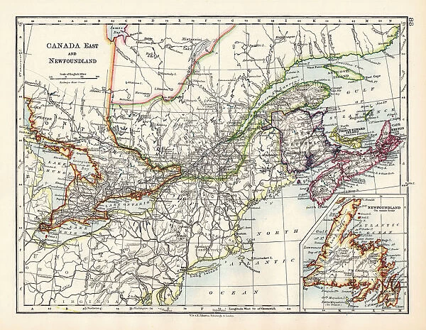
Canada map 1883
The World-Wide Atlas of Modern Geography, Political and Physical W. & A.K. Johnston - London 1897
Unleash your creativity and transform your space into a visual masterpiece!
THEPALMER
Media ID 14757138
© Roberto A Sanchez
Atlas Canada Country Geographic Area Direction Earth North Paper Patina Rusty Sepia Toned Textured Effect West Direction World Map Newfoundland Retro Styled
20"x16" (50x40cm) Canvas Print
Step back in time with our vintage Canada Map Canvas Print from Media Storehouse's Fine Art Storehouse collection. This stunning piece, titled "Canada Map 1883" by THEPALMER, is taken from The World-Wide Atlas of Modern Geography, Political and Physical by W. & A.K. Johnston, published in London in 1897. The intricate details of this antique map are beautifully rendered in high-quality canvas, creating a captivating and timeless addition to any room. Transport yourself to a bygone era with this unique and authentic work of art.
Ready to hang Premium Gloss Canvas Print. Our archival quality canvas prints are made from Polyester and Cotton mix and stretched over a 1.25" (32mm) kiln dried knot free wood stretcher bar. Packaged in a plastic bag and secured to a cardboard insert for transit.
Canvas Prints add colour, depth and texture to any space. Professionally Stretched Canvas over a hidden Wooden Box Frame and Ready to Hang
Estimated Product Size is 50.8cm x 40.6cm (20" x 16")
These are individually made so all sizes are approximate
Artwork printed orientated as per the preview above, with landscape (horizontal) orientation to match the source image.
FEATURES IN THESE COLLECTIONS
> Fine Art Storehouse
> Map
> Historical Maps
EDITORS COMMENTS
This print showcases a vintage map of Canada from the year 1883, taken from "The World-Wide Atlas of Modern Geography" by W. & A. K. Johnston in London, 1897. The retro-styled image exudes an antique charm with its engraved design and rusty patina, evoking a sense of nostalgia for the days when cartography was meticulously crafted by hand. The map itself is rich in detail, depicting the country's geographic area with precision and accuracy. From the rugged coastlines of Newfoundland to the vast expanses of land stretching towards the west direction, this piece offers a glimpse into Canada's past while also serving as a reminder of its enduring beauty. The textured effect adds depth to the print, giving it an authentic feel reminiscent of old paper that has weathered through time. Sepia-toned hues further enhance its vintage appeal, transporting viewers back to an era long gone. Whether displayed in a home or office setting, this print will undoubtedly become a conversation starter. It serves as both an educational tool and a work of art—a testament to human ingenuity and our fascination with exploring Earth's diverse landscapes.
MADE IN THE UK
Safe Shipping with 30 Day Money Back Guarantee
FREE PERSONALISATION*
We are proud to offer a range of customisation features including Personalised Captions, Color Filters and Picture Zoom Tools
SECURE PAYMENTS
We happily accept a wide range of payment options so you can pay for the things you need in the way that is most convenient for you
* Options may vary by product and licensing agreement. Zoomed Pictures can be adjusted in the Basket.


