Canvas Print > Maps and Charts > Africa
Canvas Print : Map of Suez Canal 1897


![]()
Canvas Prints from Fine Art Storehouse
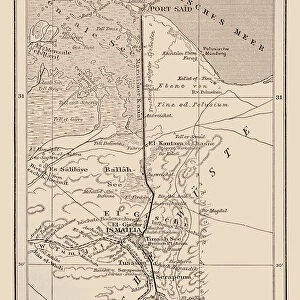
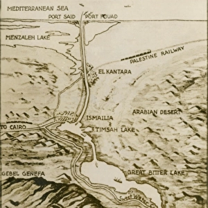
Map of Suez Canal 1897
Unleash your creativity and transform your space into a visual masterpiece!
THEPALMER
Media ID 13613565
© Roberto A Sanchez
62990 Atlas Canal Country Geographic Area Earth Ethiopia Globe Navigational Equipment Horn Of Africa Middle East Paper Suez Suez Canal World Map Ethiopian Culture Retro Styled
20"x16" (50x40cm) Canvas Print
"Step back in time with our exquisite Map of Suez Canal 1897 by THEPALMER from the Media Storehouse Fine Art Storehouse collection. This captivating canvas print showcases historical detail and intrigue, transporting you to an era of exploration and discovery. With vibrant colors and high-quality print resolution, each detail of this 1897 map is brought to life, making it a stunning addition to any home or office space. Perfect for history enthusiasts, cartography lovers, or anyone who appreciates the beauty of vintage maps, this canvas print will surely be a conversation starter. Add a touch of history and character to your decor with the Map of Suez Canal 1897 by THEPALMER from Media Storehouse's Fine Art Storehouse."
Ready to hang Premium Gloss Canvas Print. Our archival quality canvas prints are made from Polyester and Cotton mix and stretched over a 1.25" (32mm) kiln dried knot free wood stretcher bar. Packaged in a plastic bag and secured to a cardboard insert for transit.
Canvas Prints add colour, depth and texture to any space. Professionally Stretched Canvas over a hidden Wooden Box Frame and Ready to Hang
Estimated Product Size is 40.6cm x 50.8cm (16" x 20")
These are individually made so all sizes are approximate
Artwork printed orientated as per the preview above, with portrait (vertical) orientation to match the source image.
FEATURES IN THESE COLLECTIONS
> Africa
> Ethiopia (Abyssinia)
> Related Images
> Africa
> Ethiopia
> Related Images
> Africa
> Related Images
> Maps and Charts
> Related Images
> Maps and Charts
> World
> Fine Art Storehouse
> The Magical World of Illustration
> Palmer Illustrated Collection
> Fine Art Storehouse
> Map
> Historical Maps
EDITORS COMMENTS
This print titled "Map of Suez Canal 1897" takes us back in time to the late 19th century. The retro-styled, engraved image showcases a meticulously detailed map of the iconic Suez Canal, an engineering marvel that connects the Mediterranean Sea to the Red Sea. The antique charm of this piece is evident through its beautifully aged paper and intricate cartography. Every contour and waterway is delicately etched, highlighting not only the physical geography but also providing a glimpse into the world as it was over a century ago. As we explore this vintage map, our eyes are drawn to Ethiopia in Africa, reminding us of its rich cultural heritage and historical significance. This inclusion adds depth to our understanding of Ethiopian culture within its country's geographic area. Located at the crossroads between Africa and Asia, this map also captures other countries in the Middle East region known as the Horn of Africa. It serves as a reminder of how vital these trade routes were for global navigation during that era. "The Map of Suez Canal 1897" invites viewers on a journey through time, offering glimpses into both past and present worlds. Its nostalgic appeal combined with precise cartographic details makes it an exquisite addition to any collection or space where history and art converge.
MADE IN THE UK
Safe Shipping with 30 Day Money Back Guarantee
FREE PERSONALISATION*
We are proud to offer a range of customisation features including Personalised Captions, Color Filters and Picture Zoom Tools
SECURE PAYMENTS
We happily accept a wide range of payment options so you can pay for the things you need in the way that is most convenient for you
* Options may vary by product and licensing agreement. Zoomed Pictures can be adjusted in the Basket.