Antique Framed Print > Africa > Egypt > Maps
Antique Framed Print : Map of the Ancient Persian Empire


![]()
Framed Photos from Mary Evans Picture Library
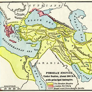
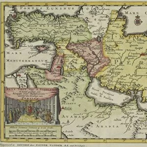
Map of the Ancient Persian Empire
Map of the Ancient Persian Empire, encompassing Greece to the north west, Arabia to the south east, Egypt and Libya to the south west and deep in the Caucasus in the north east. Date: 1798
Mary Evans Picture Library makes available wonderful images created for people to enjoy over the centuries
Media ID 11575329
© Mary Evans / Grenville Collins Postcard Collection
1798 Arabian Caucasus Chart Gulf Maps Mediterranean Persian Persians Scythia Territories Territory
14"x12" (36x31cm) Antique Frame
Bevelled wood effect frame, card mounted, 10x8 archival quality photo print. Overall outside dimensions 14x12 inches (36x31cm). Environmentally and ozone friendly, the Polycore® moulding has the look of real wood, is durable and light and easy to hang. Biodegradable and made with non-chlorinated gases (no toxic fumes) it is efficient; producing 100 tons of polystyrene can save 300 tons of trees! Prints are glazed with lightweight, shatterproof, optical clarity acrylic (providing the same general protection from the environment as glass). The back is stapled hardboard with a sawtooth hanger attached. Note: To minimise original artwork cropping, for optimum layout, and to ensure print is secure, the visible print may be marginally smaller
Bevelled Wood Effect Framed and Mounted Prints - Professionally Made and Ready to Hang
Estimated Image Size (if not cropped) is 24.4cm x 19cm (9.6" x 7.5")
Estimated Product Size is 36.3cm x 31.2cm (14.3" x 12.3")
These are individually made so all sizes are approximate
Artwork printed orientated as per the preview above, with landscape (horizontal) orientation to match the source image.
FEATURES IN THESE COLLECTIONS
> Africa
> Egypt
> Related Images
> Africa
> Libya
> Related Images
> Asia
> India
> Related Images
> Asia
> Turkey
> Related Images
> Europe
> Greece
> Related Images
> Maps and Charts
> Early Maps
> Popular Themes
> Maps and Charts
EDITORS COMMENTS
This stunning map print, created in the late 18th century, offers a captivating glimpse into the vast territories of the Ancient Persian Empire as it existed in 1798. The Persian Empire, ruled by the Persian monarchs, reached its zenith during this period, extending from Greece in the northwest, through modern-day Turkey and the Middle East, to Egypt and Libya in the southwest, deep into the Caucasus in the northeast, and even touching the Indian subcontinent. The map meticulously illustrates the empire's diverse geographical features, including the fertile plains of Mesopotamia, the rugged mountains of the Caucasus, the vast deserts of Arabia, and the shimmering waters of the Gulf Sea. The territories under Persian rule are depicted in rich detail, with cities, rivers, and mountains all clearly marked. The map also highlights the empire's strategic locations, such as the crucial trade routes that connected the Mediterranean world to the Indian subcontinent. The Persian Empire's influence extended far beyond its borders, with the Scythians to the north and India to the east also depicted on the map. This historical map is an invaluable resource for scholars, educators, and anyone interested in the ancient world. It offers a unique perspective on the size and scope of one of history's most powerful empires, and serves as a reminder of the rich cultural heritage that continues to shape our world today.
MADE IN THE UK
Safe Shipping with 30 Day Money Back Guarantee
FREE PERSONALISATION*
We are proud to offer a range of customisation features including Personalised Captions, Color Filters and Picture Zoom Tools
SECURE PAYMENTS
We happily accept a wide range of payment options so you can pay for the things you need in the way that is most convenient for you
* Options may vary by product and licensing agreement. Zoomed Pictures can be adjusted in the Basket.