Antique Framed Print : 1818, Pinkerton Map of Abyssinia, Ethiopia, Sudan and Nubia, John Pinkerton, 1758 - 1826


![]()
Framed Photos from Liszt Collection
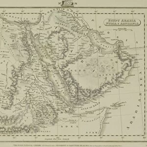
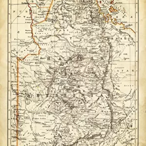
1818, Pinkerton Map of Abyssinia, Ethiopia, Sudan and Nubia, John Pinkerton, 1758 - 1826
1818, Pinkerton Map of Abyssinia, Ethiopia, Sudan and Nubia, John Pinkerton, 1758 - 1826, Scottish antiquarian, cartographer, UK
Liszt Collection of nineteenth-century engravings and images to browse and enjoy
Media ID 14004958
© Artokoloro Quint Lox Limited
1758 1826 1758 – 1826 17581826 1818 Cartographer Ethiopia John Pinkerton Scottish Antiquarian Antique Map Latitude Longitude Mappa Mundi Old Antique Plan Old Antique View Ols Antique Map Rare Old Maps Topo
14"x12" (36x31cm) Antique Frame
Bevelled wood effect frame, card mounted, 10x8 archival quality photo print. Overall outside dimensions 14x12 inches (36x31cm). Environmentally and ozone friendly, the Polycore® moulding has the look of real wood, is durable and light and easy to hang. Biodegradable and made with non-chlorinated gases (no toxic fumes) it is efficient; producing 100 tons of polystyrene can save 300 tons of trees! Prints are glazed with lightweight, shatterproof, optical clarity acrylic (providing the same general protection from the environment as glass). The back is stapled hardboard with a sawtooth hanger attached. Note: To minimise original artwork cropping, for optimum layout, and to ensure print is secure, the visible print may be marginally smaller
Bevelled Wood Effect Framed and Mounted Prints - Professionally Made and Ready to Hang
Estimated Image Size (if not cropped) is 24.4cm x 17.8cm (9.6" x 7")
Estimated Product Size is 36.3cm x 31.2cm (14.3" x 12.3")
These are individually made so all sizes are approximate
Artwork printed orientated as per the preview above, with landscape (horizontal) orientation to match the source image.
EDITORS COMMENTS
This print showcases the remarkable "1818, Pinkerton Map of Abyssinia, Ethiopia, Sudan and Nubia" created by John Pinkerton. As a Scottish antiquarian and cartographer, Pinkerton's expertise in topography and geography is evident in this exquisite piece of art. The map itself offers a fascinating glimpse into the past, revealing the intricate details of these African regions during the early 19th century. With its precise depiction of landforms, latitude and longitude gridlines, it serves as an invaluable resource for navigation and exploration. The vintage aesthetic adds to its allure; aged paper with delicate illustrations transports us back to a time when maps were meticulously crafted by hand. Its historical significance cannot be overstated - it provides insight into ancient civilizations that once thrived in these lands. As we gaze upon this rare old map from the Liszt Collection, we are reminded of the immense journey undertaken by explorers who ventured into uncharted territories. It sparks our curiosity about distant places yet to be discovered. Whether you are an avid collector or simply appreciate historical artifacts, this decorative piece will undoubtedly enrich any space with its beauty and rich narrative. Let this antique map transport you through time as you marvel at the wonders it holds within its borders.
MADE IN THE UK
Safe Shipping with 30 Day Money Back Guarantee
FREE PERSONALISATION*
We are proud to offer a range of customisation features including Personalised Captions, Color Filters and Picture Zoom Tools
SECURE PAYMENTS
We happily accept a wide range of payment options so you can pay for the things you need in the way that is most convenient for you
* Options may vary by product and licensing agreement. Zoomed Pictures can be adjusted in the Basket.