Antique Framed Print > Europe > United Kingdom > Scotland > Maps
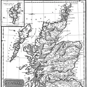
Antique Framed Print : 1772, Bonne Map of Scotland, Rigobert Bonne 1727 - 1794, one of the most important


![]()
Framed Photos from Liszt Collection
1772, Bonne Map of Scotland, Rigobert Bonne 1727 - 1794, one of the most important
1772, Bonne Map of Scotland, Rigobert Bonne 1727 - 1794, one of the most important cartographers of the late 18th century
Liszt Collection of nineteenth-century engravings and images to browse and enjoy
Media ID 14006728
© Artokoloro Quint Lox Limited
1772 Rigobert Bonne 1727 1794 Rigobert Bonne 1727 – 1794 Rigobert Bonne 17271794 Antique Map Latitude Longitude Mappa Mundi Old Antique Plan Old Antique View Ols Antique Map Rare Old Maps Topo
14"x12" (36x31cm) Antique Frame
Bevelled wood effect frame, card mounted, 10x8 archival quality photo print. Overall outside dimensions 14x12 inches (36x31cm). Environmentally and ozone friendly, the Polycore® moulding has the look of real wood, is durable and light and easy to hang. Biodegradable and made with non-chlorinated gases (no toxic fumes) it is efficient; producing 100 tons of polystyrene can save 300 tons of trees! Prints are glazed with lightweight, shatterproof, optical clarity acrylic (providing the same general protection from the environment as glass). The back is stapled hardboard with a sawtooth hanger attached. Note: To minimise original artwork cropping, for optimum layout, and to ensure print is secure, the visible print may be marginally smaller
Bevelled Wood Effect Framed and Mounted Prints - Professionally Made and Ready to Hang
Estimated Image Size (if not cropped) is 24.4cm x 17.6cm (9.6" x 6.9")
Estimated Product Size is 36.3cm x 31.2cm (14.3" x 12.3")
These are individually made so all sizes are approximate
Artwork printed orientated as per the preview above, with landscape (horizontal) orientation to match the source image.
FEATURES IN THESE COLLECTIONS
> Europe
> France
> Canton
> Landes
> Europe
> United Kingdom
> Scotland
> Maps
> Europe
> United Kingdom
> Scotland
> Posters
> Europe
> United Kingdom
> Scotland
> Related Images
> Historic
> Space exploration
> Maps and Charts
> Early Maps
> Maps and Charts
> Related Images
> Maps and Charts
> World
EDITORS COMMENTS
This vintage print showcases the remarkable 1772 Bonne Map of Scotland, created by the renowned cartographer Rigobert Bonne. Bonne, one of the most influential mapmakers of the late 18th century, meticulously crafted this masterpiece with an unwavering attention to detail. The map captures Scotland's topography and geography in exquisite fashion, providing a comprehensive illustration of its diverse landscapes and regions. Its precise depiction is a testament to Bonne's expertise in cartography and his dedication to accurately representing the world. Printed on aged paper, this historical artifact exudes an air of antiquity that transports us back to a time when exploration and discovery were at their peak. It serves as a captivating window into our past, offering glimpses into how people navigated through unknown territories centuries ago. With its decorative elements and intricate grid system indicating latitude and longitude lines, this antique map not only served practical purposes but also held artistic value. Its elegant design reflects both scientific precision and aesthetic beauty—a true mappa mundi capturing the essence of Scotland's rich history. Whether you are an avid traveler or simply fascinated by ancient maps, this rare find from the Liszt Collection is sure to ignite your curiosity about our world's past. Let it transport you on a journey through time as you explore Scotland through the eyes of Rigobert Bonne himself.
MADE IN THE UK
Safe Shipping with 30 Day Money Back Guarantee
FREE PERSONALISATION*
We are proud to offer a range of customisation features including Personalised Captions, Color Filters and Picture Zoom Tools
SECURE PAYMENTS
We happily accept a wide range of payment options so you can pay for the things you need in the way that is most convenient for you
* Options may vary by product and licensing agreement. Zoomed Pictures can be adjusted in the Basket.