Antique Framed Print > Arts > Artists > B > Willem Blaeu
Antique Framed Print : MAP: AMERICAS, c1630. A map of North and South America created by Dutch cartographer


![]()
Framed Photos from Granger
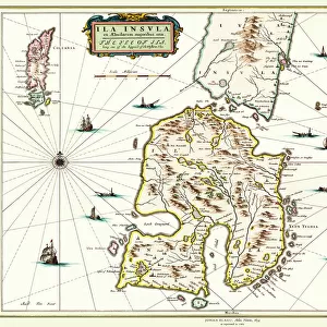
MAP: AMERICAS, c1630. A map of North and South America created by Dutch cartographer
MAP: AMERICAS, c1630.
A map of North and South America created by Dutch cartographer and atlas maker Willem Blaeu. Map, c1630
Granger holds millions of images spanning more than 25,000 years of world history, from before the Stone Age to the dawn of the Space Age
Media ID 12321418
1630 Atlas Blaeu Dutch Exploration New World North America South America Willem
14"x12" (36x31cm) Antique Frame
Bevelled wood effect frame, card mounted, 10x8 archival quality photo print. Overall outside dimensions 14x12 inches (36x31cm). Environmentally and ozone friendly, the Polycore® moulding has the look of real wood, is durable and light and easy to hang. Biodegradable and made with non-chlorinated gases (no toxic fumes) it is efficient; producing 100 tons of polystyrene can save 300 tons of trees! Prints are glazed with lightweight, shatterproof, optical clarity acrylic (providing the same general protection from the environment as glass). The back is stapled hardboard with a sawtooth hanger attached. Note: To minimise original artwork cropping, for optimum layout, and to ensure print is secure, the visible print may be marginally smaller
Bevelled Wood Effect Framed and Mounted Prints - Professionally Made and Ready to Hang
Estimated Image Size (if not cropped) is 24.4cm x 18.3cm (9.6" x 7.2")
Estimated Product Size is 36.3cm x 31.2cm (14.3" x 12.3")
These are individually made so all sizes are approximate
Artwork printed orientated as per the preview above, with landscape (horizontal) orientation to match the source image.
FEATURES IN THESE COLLECTIONS
> Arts
> Artists
> B
> Willem Blaeu
> Maps and Charts
> Early Maps
> Maps and Charts
> Related Images
> Maps and Charts
> World
> South America
> Related Images
> Granger Art on Demand
> Maps
EDITORS COMMENTS
MAP: AMERICAS, c1630. A glimpse into the early exploration of the New World". This print showcases a remarkable map of North and South America, meticulously crafted by the renowned Dutch cartographer and atlas maker, Willem Blaeu. Created in 1630, this historic piece offers a fascinating window into the early days of exploration. As we delve into this intricately detailed map, we are transported back to a time when vast territories were yet to be fully discovered and understood. Every contour line and carefully placed landmark tells a story of intrepid explorers venturing into uncharted territories. Blaeu's expertise shines through as he captures both the grandeur and diversity of these two continents. From the rugged coastlines to majestic mountain ranges, every feature is rendered with precision and artistry. It is evident that his passion for cartography was matched only by his deep curiosity about these new lands. This extraordinary map serves not only as an invaluable historical artifact but also as a testament to human ingenuity and our insatiable thirst for knowledge. It reminds us that there was once a time when much of what we now take for granted remained undiscovered. Granger Art on Demand has preserved this remarkable piece from their collection, allowing us to marvel at its beauty centuries later. Let it transport you back in time as you explore the wonders depicted within its borders – an enduring tribute to Willem Blaeu's legacy in mapping the Americas.
MADE IN THE UK
Safe Shipping with 30 Day Money Back Guarantee
FREE PERSONALISATION*
We are proud to offer a range of customisation features including Personalised Captions, Color Filters and Picture Zoom Tools
SECURE PAYMENTS
We happily accept a wide range of payment options so you can pay for the things you need in the way that is most convenient for you
* Options may vary by product and licensing agreement. Zoomed Pictures can be adjusted in the Basket.