Antique Framed Print > Fine Art Storehouse > Map
Antique Framed Print : Volcanic and Hurricane Charts; Craters; and Antarctica Engraving


![]()
Framed Photos from Fine Art Storehouse
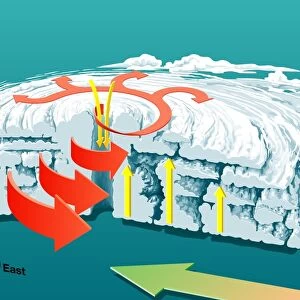
Volcanic and Hurricane Charts; Craters; and Antarctica Engraving
Engraved Illustrations of Volcanic and Hurricane Charts; Craters; and Antarctica from Iconographic Encyclopedia of Science, Literature and Art, Published in 1851. Copyright has expired on this artwork. Digitally restored
Unleash your creativity and transform your space into a visual masterpiece!
bauhaus1000
Media ID 13666757
© Craig McCausland
1850 1859 66864 78279 Arrangement Art Product Big Island Big Island Hawaii Islands Cape Peninsula Cape Town Chart Crater Diagram Drypoint Geology Globe Man Made Object Globe Navigational Equipment Graph Hawaii Islands Hurricane Storm Image Created 1850 1859 Metal Ore Organization Organizations Pacific Islands Plan Rock Strata Table Mountain National Park Table Mountain South Africa Tide Topography Volcanic Crater Volcanic Landscape Volcano Weather Western Cape Province Wind World Map Image Created 19th Century Stratification Victorian Style
14"x12" (36x31cm) Antique Frame
Bevelled wood effect frame, card mounted, 10x8 archival quality photo print. Overall outside dimensions 14x12 inches (36x31cm). Environmentally and ozone friendly, the Polycore® moulding has the look of real wood, is durable and light and easy to hang. Biodegradable and made with non-chlorinated gases (no toxic fumes) it is efficient; producing 100 tons of polystyrene can save 300 tons of trees! Prints are glazed with lightweight, shatterproof, optical clarity acrylic (providing the same general protection from the environment as glass). The back is stapled hardboard with a sawtooth hanger attached. Note: To minimise original artwork cropping, for optimum layout, and to ensure print is secure, the visible print may be marginally smaller
Bevelled Wood Effect Framed and Mounted Prints - Professionally Made and Ready to Hang
Estimated Image Size (if not cropped) is 24.4cm x 19.8cm (9.6" x 7.8")
Estimated Product Size is 36.3cm x 31.2cm (14.3" x 12.3")
These are individually made so all sizes are approximate
Artwork printed orientated as per the preview above, with landscape (horizontal) orientation to match the source image.
FEATURES IN THESE COLLECTIONS
> Fine Art Storehouse
> Map
> Historical Maps
> Fine Art Storehouse
> Map
> Italian Maps
EDITORS COMMENTS
This print showcases a collection of engraved illustrations from the Iconographic Encyclopedia of Science, Literature and Art, published in 1851. The artwork, which has been digitally restored due to its expired copyright, represents the intricate beauty of 19th-century cartography and scientific exploration. The image features an array of meticulously crafted charts and diagrams depicting volcanic landscapes, hurricane patterns, and the topography of Antarctica. Each engraving is a testament to the skillful artistry prevalent during this era. From woodcuts to etchings, these illustrations offer a glimpse into the rich history of scientific discovery. Amongst the engravings are depictions of notable landmarks such as Table Mountain in South Africa and Hawaii's Big Island volcanoes. These images provide insight into both physical geography and geology while showcasing Victorian-style artistic arrangements. Additionally, maps representing various regions including Italy and Europe can be found within this composition. The inclusion of metal ore samples further emphasizes the intersection between science and art. With no people present in these illustrations, viewers are encouraged to appreciate their aesthetic qualities purely as works of art. This print serves as a visual time capsule that transports us back to an age where meticulous craftsmanship was combined with scientific curiosity for educational purposes. Overall, this remarkable piece offers an intriguing blend of historical significance and artistic excellence that will surely captivate any admirer seeking a glimpse into our past explorations.
MADE IN THE UK
Safe Shipping with 30 Day Money Back Guarantee
FREE PERSONALISATION*
We are proud to offer a range of customisation features including Personalised Captions, Color Filters and Picture Zoom Tools
SECURE PAYMENTS
We happily accept a wide range of payment options so you can pay for the things you need in the way that is most convenient for you
* Options may vary by product and licensing agreement. Zoomed Pictures can be adjusted in the Basket.