Home > Europe > France > Canton > Landes
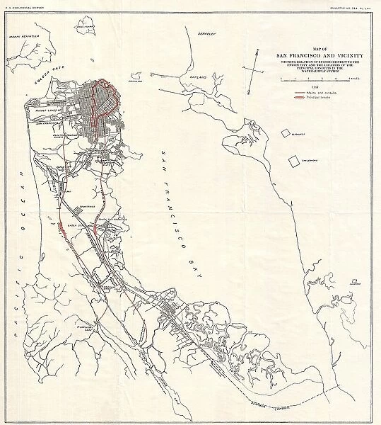
1907 Geological Survey Map Of San Francisco Peninsula After 1906 Earthquake
![]()

Wall Art and Photo Gifts from Universal Images Group (UIG)
1907 Geological Survey Map Of San Francisco Peninsula After 1906 Earthquake
1907, Geological Survey Map of San Francisco Peninsula after 1906 Earthquake
Universal Images Group (UIG) manages distribution for many leading specialist agencies worldwide
Media ID 38551999
© Artokoloro Quint Lox Limited
1907 Antique Map Latitude Longitude Mappa Mundi Old Antique Plan Old Antique View Ols Antique Map Rare Old Maps Topo
FEATURES IN THESE COLLECTIONS
> Europe
> France
> Canton
> Landes
> Historic
> Space exploration
> Maps and Charts
> Early Maps
> Maps and Charts
> Geological Map
> Maps and Charts
> Related Images
> Maps and Charts
> World
> Universal Images Group (UIG)
> History
> Historical Maps
EDITORS COMMENTS
Step back in time to 1907 and witness the devastating aftermath of the 1906 San Francisco Earthquake with this striking geological survey map. Created by the United States Geological Survey, this vintage print provides a fascinating glimpse into the topography of the San Francisco Peninsula in the years following one of California's most catastrophic natural disasters.
The map reveals a landscape forever changed by the earthquake and subsequent fires that ravaged the city. The once-thriving metropolis is now scarred by fault lines, fissures, and areas of subsidence. The cartographer's meticulous attention to detail highlights subtle changes in elevation, drainage patterns, and landforms that were altered or destroyed during the disaster.
This historic map serves as a poignant reminder of nature's fury and humanity's resilience. It also offers a unique opportunity for geographers, historians, and enthusiasts alike to explore an important chapter in California's history. With its intricate details and nostalgic charm, this vintage print is not only an educational tool but also a beautiful piece of art that can be cherished for generations to come.
MADE IN THE UK
Safe Shipping with 30 Day Money Back Guarantee
FREE PERSONALISATION*
We are proud to offer a range of customisation features including Personalised Captions, Color Filters and Picture Zoom Tools
SECURE PAYMENTS
We happily accept a wide range of payment options so you can pay for the things you need in the way that is most convenient for you
* Options may vary by product and licensing agreement. Zoomed Pictures can be adjusted in the Basket.


