Home > Arts > Artists > R > Jorge Reinel
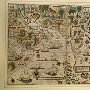
Map of Brazil, from Miller Atlas, by Pedro and Jorge Reinel, Lopo Homen, cartographers and Antonio de Holanda, miniaturist, 1519

![]()
Wall Art and Photo Gifts from Universal Images Group (UIG)
Map of Brazil, from Miller Atlas, by Pedro and Jorge Reinel, Lopo Homen, cartographers and Antonio de Holanda, miniaturist, 1519
Cartography, 16th century. Map of Brazil, from Miller Atlas, by Pedro and Jorge Reinel, Lopo Homen (cartographers) and Antonio de Holanda (miniaturist), 1519
Universal Images Group (UIG) manages distribution for many leading specialist agencies worldwide
Media ID 9572029
© DEA / G. DAGLI ORTI
16th Century Brazil Coastline Colonialism Compass Rose Direction Exploration Geography Grid Guidance Medium Group Of People Sailing Ship South America Transportation
FEATURES IN THESE COLLECTIONS
> Arts
> Artists
> R
> Jorge Reinel
> South America
> Brazil
> Maps
> Universal Images Group (UIG)
> Art
> Painting, Sculpture & Prints
> Cartography
EDITORS COMMENTS
This print showcases a remarkable piece of history - the Map of Brazil from the Miller Atlas, created by renowned cartographers Pedro and Jorge Reinel, Lopo Homen, and miniaturist Antonio de Holanda in 1519. The map is a testament to the intricate artistry and scientific precision of 16th-century cartography. The image depicts an expansive view of Brazil's coastline, with its vast stretches of land and intricate network of rivers. The map serves as a visual guide for exploration and transportation during that era, providing crucial information on direction and geography. Intriguingly, this historical artifact also reveals the colonial ambitions prevalent at the time. It symbolizes how European powers sought to expand their influence across South America through exploration and conquest. The presence of men surrounding the map suggests their involvement in navigating uncharted territories. A sailing ship depicted nearby further emphasizes the importance of maritime travel during this period. Notably absent are any depictions of women or indigenous peoples who played significant roles in shaping Brazilian history. However, it is important to recognize that this particular artwork reflects societal norms prevalent at that time rather than an accurate representation of reality. Overall, this print offers a fascinating glimpse into both the scientific advancements made in cartography during the 16th century and the complex dynamics between Europe's colonial aspirations and South America's rich cultural heritage.
MADE IN THE UK
Safe Shipping with 30 Day Money Back Guarantee
FREE PERSONALISATION*
We are proud to offer a range of customisation features including Personalised Captions, Color Filters and Picture Zoom Tools
SECURE PAYMENTS
We happily accept a wide range of payment options so you can pay for the things you need in the way that is most convenient for you
* Options may vary by product and licensing agreement. Zoomed Pictures can be adjusted in the Basket.