Tote Bag > Universal Images Group (UIG) > Universal Images Group > Satellite and Aerial > Planet Observer 5
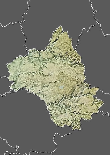
Tote Bag : Departement of Aveyron, France, Relief Map
![]()

Home Decor from Universal Images Group (UIG)
Departement of Aveyron, France, Relief Map
Relief map of the departement of Aveyron, France. It is the site of the worlds tallest bridge, the Millau viaduct. This image was compiled from data acquired by LANDSAT 5 & 7 satellites combined with elevation data
Universal Images Group (UIG) manages distribution for many leading specialist agencies worldwide
Media ID 9633573
© Planet Observer
Geographical Border Midi Pyrenees Relief Map Aveyron Satellite View
Canvas Tote Bag
Our tote bags are made from soft, durable, poly-poplin fabric and include a one inch (2.5cm) black strap for easy carrying on your shoulder. All seams are double-stitched for added durability. Each tote bag is machine-washable in cold water and is printed on both sides using the same image. Approximate size of bag is 50x33cm (20"x13")
Our tote bags are made from soft durable fabric and include a strap for easy carrying
Estimated Product Size is 32.7cm x 50cm (12.9" x 19.7")
These are individually made so all sizes are approximate
EDITORS COMMENTS
This print showcases the stunning relief map of the Departement of Aveyron in France. The intricate details captured in this image allow us to explore the physical geography and topography of this beautiful region. Nestled within Aveyron is a remarkable feat of engineering, the Millau viaduct, which proudly stands as the world's tallest bridge. Compiled from data acquired by LANDSAT 5 & 7 satellites combined with elevation data, this satellite view offers a unique perspective on Aveyron's landscape. The vibrant colors used in cartography bring life to the geographical borders and highlight the diverse terrain found throughout this area. As we gaze upon this vertical photograph, we are transported outdoors to Midi Pyrenees, where nature flourishes untouched by human presence. It is fascinating to observe how different elevations shape and define various regions within Aveyron. This print not only serves as an awe-inspiring piece of art but also provides valuable insight into one of France's most picturesque locations. Whether you are a geography enthusiast or simply appreciate breathtaking landscapes, this image will undoubtedly captivate your imagination and transport you to the scenic wonders of Aveyron.
MADE IN THE UK
Safe Shipping with 30 Day Money Back Guarantee
FREE PERSONALISATION*
We are proud to offer a range of customisation features including Personalised Captions, Color Filters and Picture Zoom Tools
SECURE PAYMENTS
We happily accept a wide range of payment options so you can pay for the things you need in the way that is most convenient for you
* Options may vary by product and licensing agreement. Zoomed Pictures can be adjusted in the Basket.


