
Tote Bag > Maps and Charts > British Empire Maps
Tote Bag : British Empire Map 1880


![]()
Home Decor from Mary Evans Picture Library
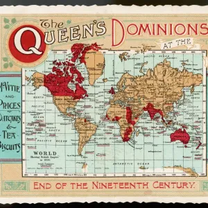
British Empire Map 1880
Map showing the extent of the British Empire circa 1880
Mary Evans Picture Library makes available wonderful images created for people to enjoy over the centuries
Media ID 608738
© Mary Evans Picture Library 2015 - https://copyrighthub.org/s0/hub1/creation/maryevans/MaryEvansPictureID/10113710
Canvas Tote Bag
Our tote bags are made from soft, durable, poly-poplin fabric and include a one inch (2.5cm) black strap for easy carrying on your shoulder. All seams are double-stitched for added durability. Each tote bag is machine-washable in cold water and is printed on both sides using the same image. Approximate size of bag is 50x33cm (20"x13")
Our tote bags are made from soft durable fabric and include a strap for easy carrying
Estimated Product Size is 50cm x 32.7cm (19.7" x 12.9")
These are individually made so all sizes are approximate
FEATURES IN THESE COLLECTIONS
> Maps and Charts
> British Empire Maps
> Maps and Charts
> Early Maps
> Maps and Charts
> Related Images
> Maps and Charts
> World
EDITORS COMMENTS
This stunning print showcases a detailed map of the British Empire in 1880, capturing the vast extent of British colonial power during this pivotal period in history. The intricate details and vibrant colors bring to life the various territories and regions under British rule, from India to Africa to Australia and beyond.
The red shading on the map highlights the sheer magnitude of influence that Britain held over a significant portion of the world at that time. It serves as a visual representation of imperial dominance and control, reflecting an era when Britannia truly ruled the waves.
As we gaze upon this historical artifact, we are transported back to a time when empires were built through conquest and colonization. The legacy of the British Empire is complex and multifaceted, with both positive contributions and negative consequences felt across the globe.
This map is not just a geographical representation but also a symbol of power, ambition, and imperialism. It reminds us of an era when borders were redrawn by force, cultures clashed, and millions of lives were forever changed by colonial expansion.
Through this print from Mary Evans Picture Library, we are given a glimpse into a world shaped by empire-building ambitions – a world where Britannia's reach truly knew no bounds.
MADE IN THE UK
Safe Shipping with 30 Day Money Back Guarantee
FREE PERSONALISATION*
We are proud to offer a range of customisation features including Personalised Captions, Color Filters and Picture Zoom Tools
SECURE PAYMENTS
We happily accept a wide range of payment options so you can pay for the things you need in the way that is most convenient for you
* Options may vary by product and licensing agreement. Zoomed Pictures can be adjusted in the Basket.


![Glasgow Central Station. Caledonian Railway [N. D]](/sq/229/glasgow-central-station-caledonian-railway-n-13155169.jpg.webp)


