
Premium Framed Print > Maps and Charts > British Empire Maps
Premium Framed Print : British Empire Map 1880


![]()
Framed Photos from Mary Evans Picture Library
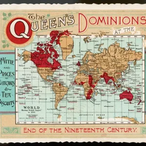
British Empire Map 1880
Map showing the extent of the British Empire circa 1880
Mary Evans Picture Library makes available wonderful images created for people to enjoy over the centuries
Media ID 608738
© Mary Evans Picture Library 2015 - https://copyrighthub.org/s0/hub1/creation/maryevans/MaryEvansPictureID/10113710
23"x19" (58x48cm) Premium Frame
FSC real wood frame with double mounted 16x12 print. Double mounted with white conservation mountboard. Frame moulding comprises stained composite natural wood veneers (Finger Jointed Pine) 39mm wide by 21mm thick. Archival quality Fujifilm CA photo paper mounted onto 1mm card. Overall outside dimensions are 23x19 inches (584x482mm). Rear features Framing tape to cover staples, 50mm Hanger plate, cork bumpers. Glazed with durable thick 2mm Acrylic to provide a virtually unbreakable glass-like finish. Acrylic Glass is far safer, more flexible and much lighter than typical mineral glass. Moreover, its higher translucency makes it a perfect carrier for photo prints. Acrylic allows a little more light to penetrate the surface than conventional glass and absorbs UV rays so that the image and the picture quality doesn't suffer under direct sunlight even after many years. Easily cleaned with a damp cloth. Please note that, to prevent the paper falling through the mount window and to prevent cropping of the original artwork, the visible print may be slightly smaller to allow the paper to be securely attached to the mount without any white edging showing and to match the aspect ratio of the original artwork.
FSC Real Wood Frame and Double Mounted with White Conservation Mountboard - Professionally Made and Ready to Hang
Estimated Image Size (if not cropped) is 39.6cm x 24.6cm (15.6" x 9.7")
Estimated Product Size is 58.4cm x 48.2cm (23" x 19")
These are individually made so all sizes are approximate
Artwork printed orientated as per the preview above, with landscape (horizontal) orientation to match the source image.
FEATURES IN THESE COLLECTIONS
> Maps and Charts
> British Empire Maps
> Maps and Charts
> Early Maps
> Maps and Charts
> Related Images
> Maps and Charts
> World
EDITORS COMMENTS
This stunning print showcases a detailed map of the British Empire in 1880, capturing the vast extent of British colonial power during this pivotal period in history. The intricate details and vibrant colors bring to life the various territories and regions under British rule, from India to Africa to Australia and beyond.
The red shading on the map highlights the sheer magnitude of influence that Britain held over a significant portion of the world at that time. It serves as a visual representation of imperial dominance and control, reflecting an era when Britannia truly ruled the waves.
As we gaze upon this historical artifact, we are transported back to a time when empires were built through conquest and colonization. The legacy of the British Empire is complex and multifaceted, with both positive contributions and negative consequences felt across the globe.
This map is not just a geographical representation but also a symbol of power, ambition, and imperialism. It reminds us of an era when borders were redrawn by force, cultures clashed, and millions of lives were forever changed by colonial expansion.
Through this print from Mary Evans Picture Library, we are given a glimpse into a world shaped by empire-building ambitions – a world where Britannia's reach truly knew no bounds.
MADE IN THE UK
Safe Shipping with 30 Day Money Back Guarantee
FREE PERSONALISATION*
We are proud to offer a range of customisation features including Personalised Captions, Color Filters and Picture Zoom Tools
SECURE PAYMENTS
We happily accept a wide range of payment options so you can pay for the things you need in the way that is most convenient for you
* Options may vary by product and licensing agreement. Zoomed Pictures can be adjusted in the Basket.


![Glasgow Central Station. Caledonian Railway [N. D]](/sq/229/glasgow-central-station-caledonian-railway-n-13155169.jpg.webp)


