
Poster Print > Maps and Charts > British Empire Maps
Poster Print : British Empire Map 1880


![]()
Poster Prints from Mary Evans Picture Library
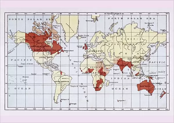
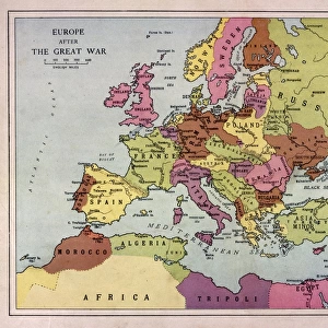
British Empire Map 1880
Map showing the extent of the British Empire circa 1880
Mary Evans Picture Library makes available wonderful images created for people to enjoy over the centuries
Media ID 608738
© Mary Evans Picture Library 2015 - https://copyrighthub.org/s0/hub1/creation/maryevans/MaryEvansPictureID/10113710
A2 (59.4 x 42cm) Poster Print
Introducing the captivating British Empire Map 1880 print from our Media Storehouse collection, brought to you by Mary Evans Picture Library. This intricately detailed map, taken from Mary Evans Prints Online, showcases the vast expanse of the British Empire at its peak around 1880. A must-have for history enthusiasts and world map collectors, this print offers a captivating glimpse into the rich and complex history of the British Empire. With its stunning visuals and historical significance, this map print is sure to make a bold and thought-provoking addition to any home or office space. Order yours today and embark on a journey through time.
A2 Poster (59.4 x 42cm, 23.4" x 16.5" inches) printed on 170gsm Satin Poster Paper. Securely packaged, rolled and inserted into a strong mailing tube and shipped tracked. Poster Prints are of comparable archival quality to our Photographic prints, they are simply printed on thinner Poster Paper. Whilst we only use Photographic Prints in our frames, you can frame Poster Prints if they are carefully supported to prevent sagging over time.
Poster prints are budget friendly enlarged prints in standard poster paper sizes (A0, A1, A2, A3 etc). Whilst poster paper is sometimes thinner and less durable than our other paper types, they are still ok for framing and should last many years. Our Archival Quality Photo Prints and Fine Art Paper Prints are printed on higher quality paper and the choice of which largely depends on your budget.
Estimated Image Size (if not cropped) is 59.4cm x 36.9cm (23.4" x 14.5")
Estimated Product Size is 59.4cm x 42cm (23.4" x 16.5")
These are individually made so all sizes are approximate
Artwork printed orientated as per the preview above, with landscape (horizontal) orientation to match the source image.
FEATURES IN THESE COLLECTIONS
> Maps and Charts
> British Empire Maps
> Maps and Charts
> Early Maps
> Maps and Charts
> Related Images
> Maps and Charts
> World
EDITORS COMMENTS
This stunning print showcases a detailed map of the British Empire in 1880, capturing the vast extent of British colonial power during this pivotal period in history. The intricate details and vibrant colors bring to life the various territories and regions under British rule, from India to Africa to Australia and beyond.
The red shading on the map highlights the sheer magnitude of influence that Britain held over a significant portion of the world at that time. It serves as a visual representation of imperial dominance and control, reflecting an era when Britannia truly ruled the waves.
As we gaze upon this historical artifact, we are transported back to a time when empires were built through conquest and colonization. The legacy of the British Empire is complex and multifaceted, with both positive contributions and negative consequences felt across the globe.
This map is not just a geographical representation but also a symbol of power, ambition, and imperialism. It reminds us of an era when borders were redrawn by force, cultures clashed, and millions of lives were forever changed by colonial expansion.
Through this print from Mary Evans Picture Library, we are given a glimpse into a world shaped by empire-building ambitions – a world where Britannia's reach truly knew no bounds.
MADE IN THE UK
Safe Shipping with 30 Day Money Back Guarantee
FREE PERSONALISATION*
We are proud to offer a range of customisation features including Personalised Captions, Color Filters and Picture Zoom Tools
SECURE PAYMENTS
We happily accept a wide range of payment options so you can pay for the things you need in the way that is most convenient for you
* Options may vary by product and licensing agreement. Zoomed Pictures can be adjusted in the Basket.


![Glasgow Central Station. Caledonian Railway [N. D]](/sq/229/glasgow-central-station-caledonian-railway-n-13155169.jpg.webp)


