Tote Bag > Europe > United Kingdom > England > London > Royalty
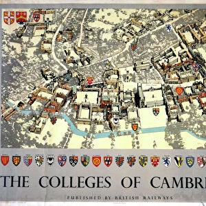
Tote Bag : Old Map of Cambridge 1898 from the Royal Atlas by Bartholomew


![]()
Home Decor from MapSeeker
Old Map of Cambridge 1898 from the Royal Atlas by Bartholomew
A fine very detailed plan of the City of Cambridge from 1898 remastered from an original contained within " The Royal Atlas of England and Wales" ; edited by J.G. Bartholomew, published by George Newnes, Limited, London
Welcome to the Mapseeker Image library and enter an historic gateway to one of the largest on-line collections of Historic Maps, Nostalgic Views, Vista's and Panorama's from a World gone by.
Media ID 20347608
Bartholomew Bartholomew Map Historic Map Old Town Plan Royal Atlas Royal Atlas Map Cambridge Cambridge City
Canvas Tote Bag
Our tote bags are made from soft, durable, poly-poplin fabric and include a one inch (2.5cm) black strap for easy carrying on your shoulder. All seams are double-stitched for added durability. Each tote bag is machine-washable in cold water and is printed on both sides using the same image. Approximate size of bag is 50x33cm (20"x13")
Our tote bags are made from soft durable fabric and include a strap for easy carrying
Estimated Product Size is 32.7cm x 50cm (12.9" x 19.7")
These are individually made so all sizes are approximate
FEATURES IN THESE COLLECTIONS
> MapSeeker
> British Town And City Plans
> English & Welsh PORTFOLIO
> Arts
> Photorealistic artworks
> Detailed art pieces
> Masterful detailing in art
> Europe
> United Kingdom
> England
> Cambridge
> Europe
> United Kingdom
> England
> London
> Royalty
> Europe
> United Kingdom
> England
> Maps
> Europe
> United Kingdom
> Wales
> Maps
> Europe
> United Kingdom
> Wales
> Posters
> Maps and Charts
> Related Images
> Maps and Charts
> Wales
EDITORS COMMENTS
This beautifully remastered print of the "Old Map of Cambridge 1898" takes us on a captivating journey back in time. A true treasure for history enthusiasts and map lovers alike, this fine and incredibly detailed plan offers a glimpse into the city's past. Originally featured in "The Royal Atlas of England and Wales" edited by J. G. Bartholomew and published by George Newnes, Limited, London, this old map showcases the intricate craftsmanship that went into cartography during that era. Every street, building, and landmark is meticulously depicted with astonishing precision. As we explore this historic town plan of Cambridge from over a century ago, we are transported to an enchanting world where horse-drawn carriages roamed the cobbled streets. The layout reveals how the city has evolved throughout time while still retaining its timeless charm. From iconic landmarks like King's College Chapel to quaint alleyways leading to hidden corners waiting to be discovered, every corner of Cambridge is brought to life through this remarkable piece of art. Whether you're a resident or visitor fascinated by local history or simply captivated by vintage maps, this print serves as both an educational resource and a stunning decorative piece for any space. It allows us to appreciate how far we've come while honoring the rich heritage that shaped our beloved city.
MADE IN THE UK
Safe Shipping with 30 Day Money Back Guarantee
FREE PERSONALISATION*
We are proud to offer a range of customisation features including Personalised Captions, Color Filters and Picture Zoom Tools
SECURE PAYMENTS
We happily accept a wide range of payment options so you can pay for the things you need in the way that is most convenient for you
* Options may vary by product and licensing agreement. Zoomed Pictures can be adjusted in the Basket.