Fine Art Print > Europe > United Kingdom > England > London > Royalty
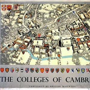
Fine Art Print : Old Map of Cambridge 1898 from the Royal Atlas by Bartholomew


![]()
Fine Art Prints from MapSeeker
Old Map of Cambridge 1898 from the Royal Atlas by Bartholomew
A fine very detailed plan of the City of Cambridge from 1898 remastered from an original contained within " The Royal Atlas of England and Wales" ; edited by J.G. Bartholomew, published by George Newnes, Limited, London
Welcome to the Mapseeker Image library and enter an historic gateway to one of the largest on-line collections of Historic Maps, Nostalgic Views, Vista's and Panorama's from a World gone by.
Media ID 20347608
Bartholomew Bartholomew Map Historic Map Old Town Plan Royal Atlas Royal Atlas Map Cambridge Cambridge City
A2 (42x59cm) Fine Art Print
Step back in time with our exquisite Old Map of Cambridge 1898 from the Media Storehouse Fine Art Prints collection. Meticulously remastered from the original contained within "The Royal Atlas of England and Wales," this fine art print showcases a detailed plan of the historic city of Cambridge as it appeared over a century ago. The Old Map of Cambridge 1898, edited by J.G, is a stunning addition to any home or office, transporting you back to an era of horse-drawn carriages and quaint architecture. Bring history to life with this beautiful and intricately detailed fine art print.
Our Fine Art Prints are printed on 100% acid free, PH neutral paper with archival properties. This printing method is used by museums and art collections to exhibit photographs and art reproductions. Hahnemühle certified studio for digital fine art printing. Printed on 308gsm Photo Rag Paper.
Our fine art prints are high-quality prints made using a paper called Photo Rag. This 100% cotton rag fibre paper is known for its exceptional image sharpness, rich colors, and high level of detail, making it a popular choice for professional photographers and artists. Photo rag paper is our clear recommendation for a fine art paper print. If you can afford to spend more on a higher quality paper, then Photo Rag is our clear recommendation for a fine art paper print.
Estimated Image Size (if not cropped) is 39.6cm x 59.4cm (15.6" x 23.4")
Estimated Product Size is 42cm x 59.4cm (16.5" x 23.4")
These are individually made so all sizes are approximate
Artwork printed orientated as per the preview above, with portrait (vertical) orientation to match the source image.
FEATURES IN THESE COLLECTIONS
> Arts
> Photorealistic artworks
> Detailed art pieces
> Masterful detailing in art
> Europe
> United Kingdom
> England
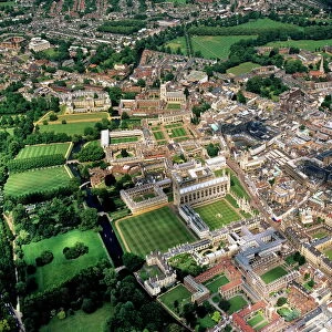
> Cambridge
> Europe
> United Kingdom
> England
> London
> Royalty
> Europe
> United Kingdom
> England
> Maps
> Europe
> United Kingdom
> Wales
> Maps
> Europe
> United Kingdom
> Wales
> Posters
> Maps and Charts
> Related Images
> Maps and Charts
> Wales
> MapSeeker
> British Town And City Plans
> English & Welsh PORTFOLIO
EDITORS COMMENTS
This beautifully remastered print of the "Old Map of Cambridge 1898" takes us on a captivating journey back in time. A true treasure for history enthusiasts and map lovers alike, this fine and incredibly detailed plan offers a glimpse into the city's past. Originally featured in "The Royal Atlas of England and Wales" edited by J. G. Bartholomew and published by George Newnes, Limited, London, this old map showcases the intricate craftsmanship that went into cartography during that era. Every street, building, and landmark is meticulously depicted with astonishing precision. As we explore this historic town plan of Cambridge from over a century ago, we are transported to an enchanting world where horse-drawn carriages roamed the cobbled streets. The layout reveals how the city has evolved throughout time while still retaining its timeless charm. From iconic landmarks like King's College Chapel to quaint alleyways leading to hidden corners waiting to be discovered, every corner of Cambridge is brought to life through this remarkable piece of art. Whether you're a resident or visitor fascinated by local history or simply captivated by vintage maps, this print serves as both an educational resource and a stunning decorative piece for any space. It allows us to appreciate how far we've come while honoring the rich heritage that shaped our beloved city.
MADE IN THE UK
Safe Shipping with 30 Day Money Back Guarantee
FREE PERSONALISATION*
We are proud to offer a range of customisation features including Personalised Captions, Color Filters and Picture Zoom Tools
SECURE PAYMENTS
We happily accept a wide range of payment options so you can pay for the things you need in the way that is most convenient for you
* Options may vary by product and licensing agreement. Zoomed Pictures can be adjusted in the Basket.