Tote Bag > North America > United States of America > Massachusetts > Boston
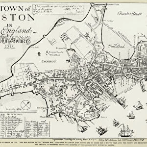
Tote Bag : BOSTON: MAP, 1775-1776. Map of Boston, Massachusetts, and the surrounding area, 1775-1776. Line engraving, 19th century


![]()
Home Decor from Granger
BOSTON: MAP, 1775-1776. Map of Boston, Massachusetts, and the surrounding area, 1775-1776. Line engraving, 19th century
BOSTON: MAP, 1775-1776.
Map of Boston, Massachusetts, and the surrounding area, 1775-1776. Line engraving, 19th century
Granger holds millions of images spanning more than 25,000 years of world history, from before the Stone Age to the dawn of the Space Age
Media ID 6181540
1775 1776 American Revolution Boston Colony Rebellion Revolutionary Topography
Canvas Tote Bag
Our tote bags are made from soft, durable, poly-poplin fabric and include a one inch (2.5cm) black strap for easy carrying on your shoulder. All seams are double-stitched for added durability. Each tote bag is machine-washable in cold water and is printed on both sides using the same image. Approximate size of bag is 50x33cm (20"x13")
Our tote bags are made from soft durable fabric and include a strap for easy carrying
Estimated Product Size is 32.7cm x 50cm (12.9" x 19.7")
These are individually made so all sizes are approximate
FEATURES IN THESE COLLECTIONS
> Granger Art on Demand
> Boston Maps and Views
> Maps and Charts
> Related Images
> North America
> United States of America
> Massachusetts
> Boston
BOSTON - MAP, 1775-1776
EDITORS COMMENTS
is a captivating print that takes us back in time to the heart of the American Revolution. This line engraving, created in the 19th century, showcases a meticulously detailed map of Boston and its surrounding area during the years 1775-1776. The sepia tones add an air of nostalgia and authenticity to this historical piece. As we gaze upon this map, we are transported to a pivotal moment in history when Boston was at the center of rebellion against British rule. Every intricate detail on this print tells a story - from the winding streets and neighborhoods to the meandering river that played witness to countless revolutionary events. The significance of this map lies not only in its topographical accuracy but also in its representation of a city on the brink of change. It serves as a visual reminder of how Boston transformed from a loyal colony into one that ignited the flames of revolution. This Granger Collection artwork captures both our curiosity and imagination as we explore every inch with awe-inspiring wonderment. It invites us to delve into history's pages and relive those tumultuous times when brave men and women fought for their freedom. Whether you are an avid historian or simply appreciate art that transports you through time, "BOSTON: MAP, 1775-1776" is sure to captivate your senses and ignite your passion for America's rich revolutionary past.
MADE IN THE UK
Safe Shipping with 30 Day Money Back Guarantee
FREE PERSONALISATION*
We are proud to offer a range of customisation features including Personalised Captions, Color Filters and Picture Zoom Tools
SECURE PAYMENTS
We happily accept a wide range of payment options so you can pay for the things you need in the way that is most convenient for you
* Options may vary by product and licensing agreement. Zoomed Pictures can be adjusted in the Basket.