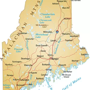
Fine Art Print > North America > United States of America > Massachusetts > Boston
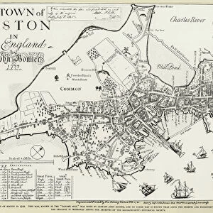
Fine Art Print : BOSTON: MAP, 1775-1776. Map of Boston, Massachusetts, and the surrounding area, 1775-1776. Line engraving, 19th century


![]()
Fine Art Prints from Granger
BOSTON: MAP, 1775-1776. Map of Boston, Massachusetts, and the surrounding area, 1775-1776. Line engraving, 19th century
BOSTON: MAP, 1775-1776.
Map of Boston, Massachusetts, and the surrounding area, 1775-1776. Line engraving, 19th century
Granger holds millions of images spanning more than 25,000 years of world history, from before the Stone Age to the dawn of the Space Age
Media ID 6181540
1775 1776 American Revolution Boston Colony Rebellion Revolutionary Topography
A2 (42x59cm) Fine Art Print
Step back in time with our exquisite Fine Art Print of Boston: MAP, 1775-1776. This intricately detailed line engraving, hailing from the 19th century, offers a captivating glimpse into the historical landscape of Boston, Massachusetts, and its surrounding areas during a pivotal period in American history. The Granger Collection's masterpiece, now available as a Fine Art Print from Media Storehouse, invites you to explore the streets of Boston as they appeared during the events leading up to the American Revolution. Add this stunning piece to your collection and bring a piece of history into your home or office.
Our Fine Art Prints are printed on 100% acid free, PH neutral paper with archival properties. This printing method is used by museums and art collections to exhibit photographs and art reproductions. Hahnemühle certified studio for digital fine art printing. Printed on 308gsm Photo Rag Paper.
Our fine art prints are high-quality prints made using a paper called Photo Rag. This 100% cotton rag fibre paper is known for its exceptional image sharpness, rich colors, and high level of detail, making it a popular choice for professional photographers and artists. Photo rag paper is our clear recommendation for a fine art paper print. If you can afford to spend more on a higher quality paper, then Photo Rag is our clear recommendation for a fine art paper print.
Estimated Image Size (if not cropped) is 40.5cm x 59.4cm (15.9" x 23.4")
Estimated Product Size is 42cm x 59.4cm (16.5" x 23.4")
These are individually made so all sizes are approximate
Artwork printed orientated as per the preview above, with portrait (vertical) orientation to match the source image.
FEATURES IN THESE COLLECTIONS
> Maps and Charts
> Related Images
> North America
> United States of America
> Massachusetts
> Boston
> Granger Art on Demand
> Boston Maps and Views
BOSTON - MAP, 1775-1776
EDITORS COMMENTS
is a captivating print that takes us back in time to the heart of the American Revolution. This line engraving, created in the 19th century, showcases a meticulously detailed map of Boston and its surrounding area during the years 1775-1776. The sepia tones add an air of nostalgia and authenticity to this historical piece. As we gaze upon this map, we are transported to a pivotal moment in history when Boston was at the center of rebellion against British rule. Every intricate detail on this print tells a story - from the winding streets and neighborhoods to the meandering river that played witness to countless revolutionary events. The significance of this map lies not only in its topographical accuracy but also in its representation of a city on the brink of change. It serves as a visual reminder of how Boston transformed from a loyal colony into one that ignited the flames of revolution. This Granger Collection artwork captures both our curiosity and imagination as we explore every inch with awe-inspiring wonderment. It invites us to delve into history's pages and relive those tumultuous times when brave men and women fought for their freedom. Whether you are an avid historian or simply appreciate art that transports you through time, "BOSTON: MAP, 1775-1776" is sure to captivate your senses and ignite your passion for America's rich revolutionary past.
MADE IN THE UK
Safe Shipping with 30 Day Money Back Guarantee
FREE PERSONALISATION*
We are proud to offer a range of customisation features including Personalised Captions, Color Filters and Picture Zoom Tools
SECURE PAYMENTS
We happily accept a wide range of payment options so you can pay for the things you need in the way that is most convenient for you
* Options may vary by product and licensing agreement. Zoomed Pictures can be adjusted in the Basket.