Tote Bag > Europe > United Kingdom > England > Merseyside > Liverpool
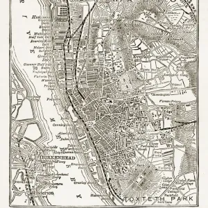
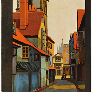
Tote Bag : Map of Liverpool and its environs, England, 1870s


![]()
Home Decor from Fine Art Storehouse
Map of Liverpool and its environs, England, 1870s
Vintage engraving of Map of Liverpool and its environs, England, 1870s, 19th Century
Unleash your creativity and transform your space into a visual masterpiece!
duncan1890
Media ID 15231375
© This content is subject to copyright
1870s Equipment Great Britain Human Settlement Liverpool Merseyside Navigational Equipment North West England Northern Europe Retro Road Map Styles Supplies United Kingdom Victorian Mersey
Canvas Tote Bag
Our tote bags are made from soft, durable, poly-poplin fabric and include a one inch (2.5cm) black strap for easy carrying on your shoulder. All seams are double-stitched for added durability. Each tote bag is machine-washable in cold water and is printed on both sides using the same image. Approximate size of bag is 50x33cm (20"x13")
Our tote bags are made from soft durable fabric and include a strap for easy carrying
Estimated Product Size is 50cm x 32.7cm (19.7" x 12.9")
These are individually made so all sizes are approximate
FEATURES IN THESE COLLECTIONS
> Fine Art Storehouse
> Map
> Historical Maps
> Arts
> Landscape paintings
> Waterfall and river artworks
> River artworks
> Europe
> Related Images
> Europe
> United Kingdom
> England
> Liverpool
> Europe
> United Kingdom
> England
> Maps
> Europe
> United Kingdom
> England
> Merseyside
> Liverpool
> Europe
> United Kingdom
> England
> Merseyside
> Related Images
> Europe
> United Kingdom
> England
> Paintings
> Europe
> United Kingdom
> England
> Posters
> Europe
> United Kingdom
> England
> Related Images
> Europe
> United Kingdom
> England
> Rivers
EDITORS COMMENTS
This vintage engraving of a Map of Liverpool and its environs, England, from the 1870s takes us back to the bustling city in the heart of 19th century Britain. The print captures the essence of this historic era with its intricate details and old-fashioned charm. The map showcases Liverpool's strategic location along the River Mersey, highlighting its significance as a major port city in Northern Europe. It offers a glimpse into the past, revealing how human settlement and industrialization shaped this vibrant metropolis during Victorian times. With meticulous precision, this woodcut illustration presents an array of navigational equipment used by sailors and cartographers at that time. It serves as a testament to their dedication in mapping out cities like Liverpool for trade and exploration purposes. As we study this antique road map, we are transported back to an era when supplies were transported via river routes rather than modern highways. The print evokes nostalgia for a bygone era while reminding us of Liverpool's rich history as an economic powerhouse. Duncan1890's captivating artwork allows us to appreciate not only the beauty but also the historical significance embedded within every stroke. This print is truly a treasure for those who admire both artistry and history alike.
MADE IN THE UK
Safe Shipping with 30 Day Money Back Guarantee
FREE PERSONALISATION*
We are proud to offer a range of customisation features including Personalised Captions, Color Filters and Picture Zoom Tools
SECURE PAYMENTS
We happily accept a wide range of payment options so you can pay for the things you need in the way that is most convenient for you
* Options may vary by product and licensing agreement. Zoomed Pictures can be adjusted in the Basket.